You are here: Home > Network List > GS - US Geological Survey Networks Stations List
> Station OK051 E0350 and S34600 Roads, Ralston, OK > Earthquake Result Viewer
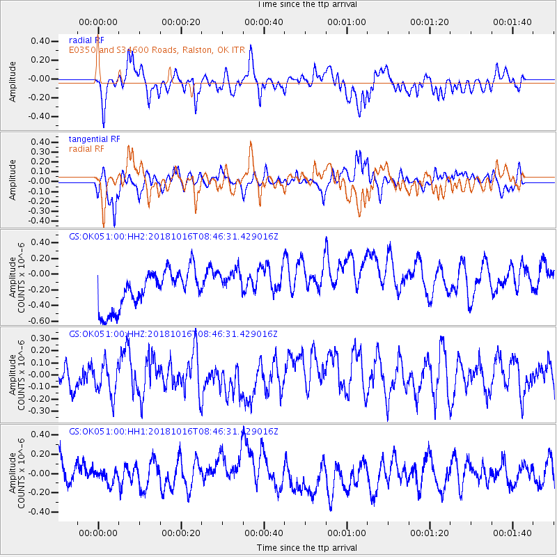
OK051 E0350 and S34600 Roads, Ralston, OK - Earthquake Result Viewer
*The percent match for this event was below the threshold and hence no stack was calculated.
| Earthquake location: |
Central Mid-Atlantic Ridge |
| Earthquake latitude/longitude: |
0.9/-28.2 |
| Earthquake time(UTC): |
2018/10/16 (289) 08:35:37 GMT |
| Earthquake Depth: |
10 km |
| Earthquake Magnitude: |
5.3 mb |
| Earthquake Catalog/Contributor: |
NEIC PDE/us |
|
| Network: |
GS US Geological Survey Networks |
| Station: |
OK051 E0350 and S34600 Roads, Ralston, OK |
| Lat/Lon: |
36.51 N/96.84 W |
| Elevation: |
263 m |
|
| Distance: |
72.3 deg |
| Az: |
308.064 deg |
| Baz: |
102.3 deg |
| Ray Param: |
$rayparam |
*The percent match for this event was below the threshold and hence was not used in the summary stack. |
|
| Radial Match: |
49.7523 % |
| Radial Bump: |
400 |
| Transverse Match: |
61.077778 % |
| Transverse Bump: |
385 |
| SOD ConfigId: |
3045211 |
| Insert Time: |
2018-10-30 08:47:05.726 +0000 |
| GWidth: |
2.5 |
| Max Bumps: |
400 |
| Tol: |
0.001 |
|
Signal To Noise
| Channel | StoN | STA | LTA |
| GS:OK051:00:HHZ:20181016T08:46:31.429016Z | 0.9737075 | 1.343642E-7 | 1.3799236E-7 |
| GS:OK051:00:HH1:20181016T08:46:31.429016Z | 0.40967327 | 7.5193746E-8 | 1.8354565E-7 |
| GS:OK051:00:HH2:20181016T08:46:31.429016Z | 0.83145285 | 1.9702317E-7 | 2.3696252E-7 |
| Arrivals |
| Ps | |
| PpPs | |
| PsPs/PpSs | |


