You are here: Home > Network List > CI - Caltech Regional Seismic Network Stations List
> Station FMP Fort MacArthur Park, Pt. Fermin San Pedro, CA, USA > Earthquake Result Viewer
FMP Fort MacArthur Park, Pt. Fermin San Pedro, CA, USA - Earthquake Result Viewer
| Earthquake location: |
South Of Fiji Islands |
| Earthquake latitude/longitude: |
-25.1/178.5 |
| Earthquake time(UTC): |
2023/04/28 (118) 03:13:43 GMT |
| Earthquake Depth: |
577 km |
| Earthquake Magnitude: |
6.2 mb |
| Earthquake Catalog/Contributor: |
NEIC PDE/us |
|
| Network: |
CI Caltech Regional Seismic Network |
| Station: |
FMP Fort MacArthur Park, Pt. Fermin San Pedro, CA, USA |
| Lat/Lon: |
33.71 N/118.29 W |
| Elevation: |
89 m |
|
| Distance: |
83.9 deg |
| Az: |
48.47 deg |
| Baz: |
234.508 deg |
| Ray Param: |
0.044203416 |
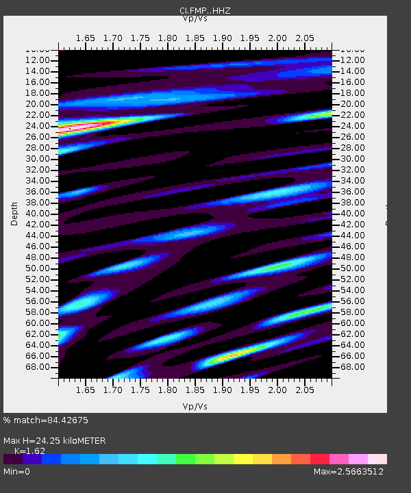
| Estimated Moho Depth: |
24.25 km |
| Estimated Crust Vp/Vs: |
1.62 |
| Assumed Crust Vp: |
6.048 km/s |
| Estimated Crust Vs: |
3.733 km/s |
| Estimated Crust Poisson's Ratio: |
0.19 |
|
| Radial Match: |
84.42675 % |
| Radial Bump: |
400 |
| Transverse Match: |
83.8963 % |
| Transverse Bump: |
400 |
| SOD ConfigId: |
30536071 |
| Insert Time: |
2023-05-12 03:27:24.845 +0000 |
| GWidth: |
2.5 |
| Max Bumps: |
400 |
| Tol: |
0.001 |
|

Signal To Noise
| Channel | StoN | STA | LTA |
| CI:FMP: :HHZ:20230428T03:24:42.308024Z | 5.817842 | 1.5666031E-6 | 2.6927563E-7 |
| CI:FMP: :HHN:20230428T03:24:42.308024Z | 2.041824 | 9.835093E-7 | 4.816817E-7 |
| CI:FMP: :HHE:20230428T03:24:42.308024Z | 1.7591844 | 1.1110183E-6 | 6.3155306E-7 |
| Arrivals |
| Ps | 2.5 SECOND |
| PpPs | 10 SECOND |
| PsPs/PpSs | 13 SECOND |


