You are here: Home > Network List > US - United States National Seismic Network Stations List
> Station WMOK Wichita Mountains, Oklahoma, USA > Earthquake Result Viewer
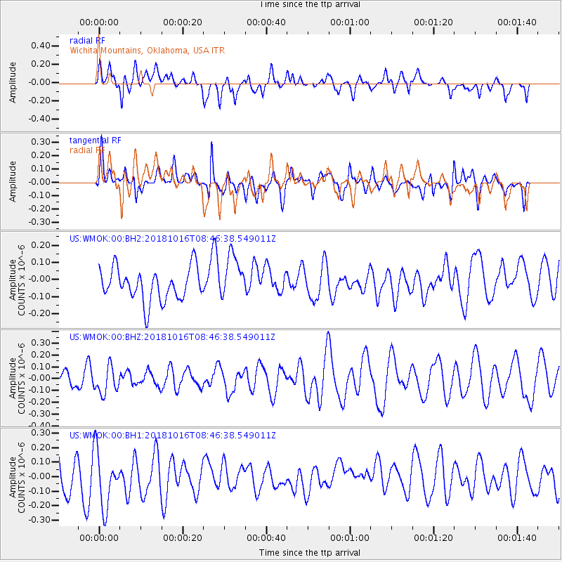
WMOK Wichita Mountains, Oklahoma, USA - Earthquake Result Viewer
*The percent match for this event was below the threshold and hence no stack was calculated.
| Earthquake location: |
Central Mid-Atlantic Ridge |
| Earthquake latitude/longitude: |
0.9/-28.2 |
| Earthquake time(UTC): |
2018/10/16 (289) 08:35:37 GMT |
| Earthquake Depth: |
10 km |
| Earthquake Magnitude: |
5.3 mb |
| Earthquake Catalog/Contributor: |
NEIC PDE/us |
|
| Network: |
US United States National Seismic Network |
| Station: |
WMOK Wichita Mountains, Oklahoma, USA |
| Lat/Lon: |
34.74 N/98.78 W |
| Elevation: |
486 m |
|
| Distance: |
73.5 deg |
| Az: |
305.928 deg |
| Baz: |
100.545 deg |
| Ray Param: |
$rayparam |
*The percent match for this event was below the threshold and hence was not used in the summary stack. |
|
| Radial Match: |
48.15148 % |
| Radial Bump: |
400 |
| Transverse Match: |
51.39301 % |
| Transverse Bump: |
400 |
| SOD ConfigId: |
3045211 |
| Insert Time: |
2018-10-30 08:50:46.487 +0000 |
| GWidth: |
2.5 |
| Max Bumps: |
400 |
| Tol: |
0.001 |
|
Signal To Noise
| Channel | StoN | STA | LTA |
| US:WMOK:00:BHZ:20181016T08:46:38.549011Z | 1.168153 | 1.1546152E-7 | 9.8841085E-8 |
| US:WMOK:00:BH1:20181016T08:46:38.549011Z | 2.0161197 | 1.9427026E-7 | 9.635849E-8 |
| US:WMOK:00:BH2:20181016T08:46:38.549011Z | 1.4226878 | 1.3419664E-7 | 9.432613E-8 |
| Arrivals |
| Ps | |
| PpPs | |
| PsPs/PpSs | |


