You are here: Home > Network List > IU - Global Seismograph Network (GSN - IRIS/USGS) Stations List
> Station PMG Port Moresby, New Guinea > Earthquake Result Viewer
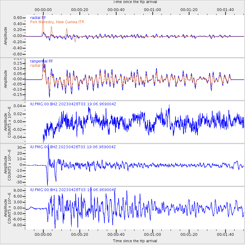
PMG Port Moresby, New Guinea - Earthquake Result Viewer
*The percent match for this event was below the threshold and hence no stack was calculated.
| Earthquake location: |
South Of Fiji Islands |
| Earthquake latitude/longitude: |
-25.1/178.5 |
| Earthquake time(UTC): |
2023/04/28 (118) 03:13:43 GMT |
| Earthquake Depth: |
577 km |
| Earthquake Magnitude: |
6.2 mb |
| Earthquake Catalog/Contributor: |
NEIC PDE/us |
|
| Network: |
IU Global Seismograph Network (GSN - IRIS/USGS) |
| Station: |
PMG Port Moresby, New Guinea |
| Lat/Lon: |
9.40 S/147.16 E |
| Elevation: |
90 m |
|
| Distance: |
33.6 deg |
| Az: |
292.146 deg |
| Baz: |
121.681 deg |
| Ray Param: |
$rayparam |
*The percent match for this event was below the threshold and hence was not used in the summary stack. |
|
| Radial Match: |
79.65093 % |
| Radial Bump: |
400 |
| Transverse Match: |
79.82289 % |
| Transverse Bump: |
400 |
| SOD ConfigId: |
30536071 |
| Insert Time: |
2023-05-12 03:31:53.641 +0000 |
| GWidth: |
2.5 |
| Max Bumps: |
400 |
| Tol: |
0.001 |
|
Signal To Noise
| Channel | StoN | STA | LTA |
| IU:PMG:00:BHZ:20230428T03:19:06.969004Z | 65.21146 | 1.2299256E-5 | 1.8860574E-7 |
| IU:PMG:00:BH1:20230428T03:19:06.969004Z | 11.1583805 | 2.7190858E-6 | 2.4368103E-7 |
| IU:PMG:00:BH2:20230428T03:19:06.969004Z | 0.95348257 | 1.4416187E-8 | 1.5119507E-8 |
| Arrivals |
| Ps | |
| PpPs | |
| PsPs/PpSs | |


