You are here: Home > Network List > PY - PFO Array Stations List
> Station BPH07 Pinon Flat Observatory, CA, USA > Earthquake Result Viewer
BPH07 Pinon Flat Observatory, CA, USA - Earthquake Result Viewer
| Earthquake location: |
South Of Fiji Islands |
| Earthquake latitude/longitude: |
-25.1/178.5 |
| Earthquake time(UTC): |
2023/04/28 (118) 03:13:43 GMT |
| Earthquake Depth: |
577 km |
| Earthquake Magnitude: |
6.2 mb |
| Earthquake Catalog/Contributor: |
NEIC PDE/us |
|
| Network: |
PY PFO Array |
| Station: |
BPH07 Pinon Flat Observatory, CA, USA |
| Lat/Lon: |
33.61 N/116.46 W |
| Elevation: |
1275 m |
|
| Distance: |
85.1 deg |
| Az: |
49.438 deg |
| Baz: |
235.616 deg |
| Ray Param: |
0.04337012 |
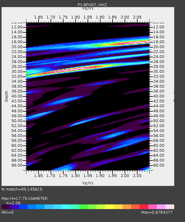
| Estimated Moho Depth: |
17.75 km |
| Estimated Crust Vp/Vs: |
2.08 |
| Assumed Crust Vp: |
6.264 km/s |
| Estimated Crust Vs: |
3.011 km/s |
| Estimated Crust Poisson's Ratio: |
0.35 |
|
| Radial Match: |
85.145615 % |
| Radial Bump: |
400 |
| Transverse Match: |
77.74657 % |
| Transverse Bump: |
400 |
| SOD ConfigId: |
30536071 |
| Insert Time: |
2023-05-12 03:34:59.957 +0000 |
| GWidth: |
2.5 |
| Max Bumps: |
400 |
| Tol: |
0.001 |
|

Signal To Noise
| Channel | StoN | STA | LTA |
| PY:BPH07: :HHZ:20230428T03:24:48.126017Z | 6.1462827 | 7.51626E-7 | 1.2228952E-7 |
| PY:BPH07: :HHN:20230428T03:24:48.126017Z | 1.5424502 | 1.4014246E-7 | 9.085704E-8 |
| PY:BPH07: :HHE:20230428T03:24:48.126017Z | 2.3017907 | 1.8062568E-7 | 7.84718E-8 |
| Arrivals |
| Ps | 3.1 SECOND |
| PpPs | 8.6 SECOND |
| PsPs/PpSs | 12 SECOND |


