You are here: Home > Network List > SB - UC Santa Barbara Engineering Seismology Network () Stations List
> Station VAFB1 Globe Rd, Vandenberg AFB, CA, USA > Earthquake Result Viewer
VAFB1 Globe Rd, Vandenberg AFB, CA, USA - Earthquake Result Viewer
| Earthquake location: |
South Of Fiji Islands |
| Earthquake latitude/longitude: |
-25.1/178.5 |
| Earthquake time(UTC): |
2023/04/28 (118) 03:13:43 GMT |
| Earthquake Depth: |
577 km |
| Earthquake Magnitude: |
6.2 mb |
| Earthquake Catalog/Contributor: |
NEIC PDE/us |
|
| Network: |
SB UC Santa Barbara Engineering Seismology Network () |
| Station: |
VAFB1 Globe Rd, Vandenberg AFB, CA, USA |
| Lat/Lon: |
34.86 N/120.60 W |
| Elevation: |
121 m |
|
| Distance: |
83.0 deg |
| Az: |
46.407 deg |
| Baz: |
232.979 deg |
| Ray Param: |
0.044787634 |
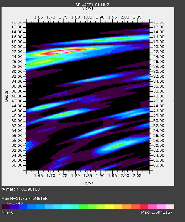
| Estimated Moho Depth: |
21.75 km |
| Estimated Crust Vp/Vs: |
1.75 |
| Assumed Crust Vp: |
6.183 km/s |
| Estimated Crust Vs: |
3.543 km/s |
| Estimated Crust Poisson's Ratio: |
0.26 |
|
| Radial Match: |
82.98183 % |
| Radial Bump: |
314 |
| Transverse Match: |
71.8377 % |
| Transverse Bump: |
400 |
| SOD ConfigId: |
30536071 |
| Insert Time: |
2023-05-12 03:36:15.160 +0000 |
| GWidth: |
2.5 |
| Max Bumps: |
400 |
| Tol: |
0.001 |
|

Signal To Noise
| Channel | StoN | STA | LTA |
| SB:VAFB1:01:HHZ:20230428T03:24:38.045023Z | 4.107886 | 9.717595E-7 | 2.3655953E-7 |
| SB:VAFB1:01:HHN:20230428T03:24:38.045023Z | 1.9822828 | 3.9438166E-7 | 1.9895327E-7 |
| SB:VAFB1:01:HHE:20230428T03:24:38.045023Z | 1.3025512 | 3.792253E-7 | 2.9114042E-7 |
| Arrivals |
| Ps | 2.7 SECOND |
| PpPs | 9.4 SECOND |
| PsPs/PpSs | 12 SECOND |


