You are here: Home > Network List > TM - Thai Seismic Monitoring Network Stations List
> Station SRIT Phipun, Nakhon Si Thammarat > Earthquake Result Viewer
SRIT Phipun, Nakhon Si Thammarat - Earthquake Result Viewer
| Earthquake location: |
South Of Fiji Islands |
| Earthquake latitude/longitude: |
-25.1/178.5 |
| Earthquake time(UTC): |
2023/04/28 (118) 03:13:43 GMT |
| Earthquake Depth: |
577 km |
| Earthquake Magnitude: |
6.2 mb |
| Earthquake Catalog/Contributor: |
NEIC PDE/us |
|
| Network: |
TM Thai Seismic Monitoring Network |
| Station: |
SRIT Phipun, Nakhon Si Thammarat |
| Lat/Lon: |
8.60 N/99.60 E |
| Elevation: |
77 m |
|
| Distance: |
83.7 deg |
| Az: |
282.508 deg |
| Baz: |
116.494 deg |
| Ray Param: |
0.04434261 |
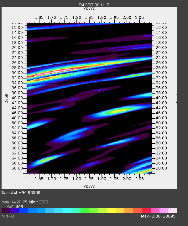
| Estimated Moho Depth: |
29.75 km |
| Estimated Crust Vp/Vs: |
1.70 |
| Assumed Crust Vp: |
6.468 km/s |
| Estimated Crust Vs: |
3.816 km/s |
| Estimated Crust Poisson's Ratio: |
0.23 |
|
| Radial Match: |
90.96569 % |
| Radial Bump: |
400 |
| Transverse Match: |
85.90956 % |
| Transverse Bump: |
400 |
| SOD ConfigId: |
30536071 |
| Insert Time: |
2023-05-12 03:36:51.950 +0000 |
| GWidth: |
2.5 |
| Max Bumps: |
400 |
| Tol: |
0.001 |
|

Signal To Noise
| Channel | StoN | STA | LTA |
| TM:SRIT:00:HHZ:20230428T03:24:41.309977Z | 75.32148 | 5.8211995E-6 | 7.728472E-8 |
| TM:SRIT:00:HHN:20230428T03:24:41.309977Z | 12.912578 | 1.4148131E-6 | 1.0956861E-7 |
| TM:SRIT:00:HHE:20230428T03:24:41.309977Z | 13.855837 | 1.6456096E-6 | 1.1876652E-7 |
| Arrivals |
| Ps | 3.3 SECOND |
| PpPs | 12 SECOND |
| PsPs/PpSs | 15 SECOND |


