You are here: Home > Network List > US - United States National Seismic Network Stations List
> Station DUG Dugway, Tooele County, Utah, USA > Earthquake Result Viewer
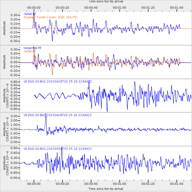
DUG Dugway, Tooele County, Utah, USA - Earthquake Result Viewer
*The percent match for this event was below the threshold and hence no stack was calculated.
| Earthquake location: |
South Of Fiji Islands |
| Earthquake latitude/longitude: |
-25.1/178.5 |
| Earthquake time(UTC): |
2023/04/28 (118) 03:13:43 GMT |
| Earthquake Depth: |
577 km |
| Earthquake Magnitude: |
6.2 mb |
| Earthquake Catalog/Contributor: |
NEIC PDE/us |
|
| Network: |
US United States National Seismic Network |
| Station: |
DUG Dugway, Tooele County, Utah, USA |
| Lat/Lon: |
40.19 N/112.81 W |
| Elevation: |
1477 m |
|
| Distance: |
91.1 deg |
| Az: |
45.555 deg |
| Baz: |
237.667 deg |
| Ray Param: |
$rayparam |
*The percent match for this event was below the threshold and hence was not used in the summary stack. |
|
| Radial Match: |
79.596275 % |
| Radial Bump: |
400 |
| Transverse Match: |
73.598694 % |
| Transverse Bump: |
400 |
| SOD ConfigId: |
30536071 |
| Insert Time: |
2023-05-12 03:39:20.275 +0000 |
| GWidth: |
2.5 |
| Max Bumps: |
400 |
| Tol: |
0.001 |
|
Signal To Noise
| Channel | StoN | STA | LTA |
| US:DUG:00:BHZ:20230428T03:25:16.324992Z | 3.2572713 | 2.5919783E-7 | 7.957514E-8 |
| US:DUG:00:BH1:20230428T03:25:16.324992Z | 1.8056155 | 1.14719185E-7 | 6.3534664E-8 |
| US:DUG:00:BH2:20230428T03:25:16.324992Z | 1.0540695 | 1.08446784E-7 | 1.028839E-7 |
| Arrivals |
| Ps | |
| PpPs | |
| PsPs/PpSs | |


