You are here: Home > Network List > UU - University of Utah Regional Network Stations List
> Station FOR7 FORGE > Earthquake Result Viewer
FOR7 FORGE - Earthquake Result Viewer
| Earthquake location: |
South Of Fiji Islands |
| Earthquake latitude/longitude: |
-25.1/178.5 |
| Earthquake time(UTC): |
2023/04/28 (118) 03:13:43 GMT |
| Earthquake Depth: |
577 km |
| Earthquake Magnitude: |
6.2 mb |
| Earthquake Catalog/Contributor: |
NEIC PDE/us |
|
| Network: |
UU University of Utah Regional Network |
| Station: |
FOR7 FORGE |
| Lat/Lon: |
38.42 N/112.85 W |
| Elevation: |
1964 m |
|
| Distance: |
90.1 deg |
| Az: |
47.035 deg |
| Baz: |
237.626 deg |
| Ray Param: |
0.04147559 |
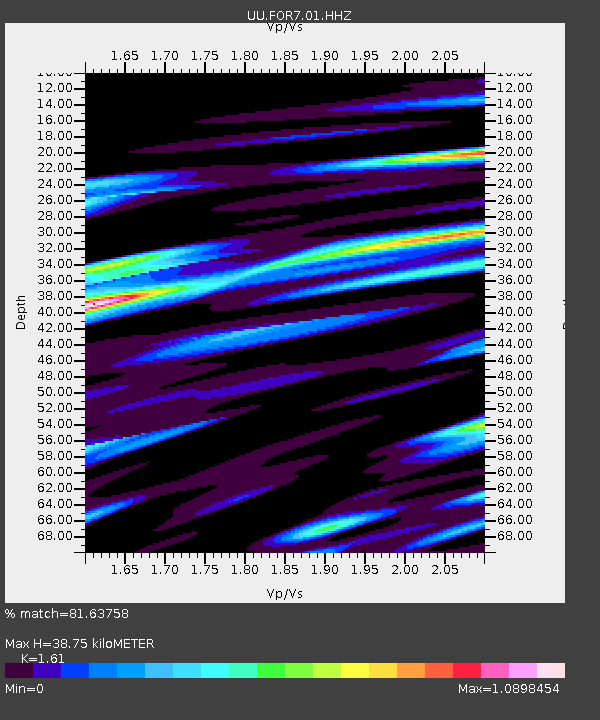
| Estimated Moho Depth: |
38.75 km |
| Estimated Crust Vp/Vs: |
1.61 |
| Assumed Crust Vp: |
6.276 km/s |
| Estimated Crust Vs: |
3.898 km/s |
| Estimated Crust Poisson's Ratio: |
0.19 |
|
| Radial Match: |
81.63758 % |
| Radial Bump: |
400 |
| Transverse Match: |
80.19956 % |
| Transverse Bump: |
400 |
| SOD ConfigId: |
30536071 |
| Insert Time: |
2023-05-12 03:39:53.911 +0000 |
| GWidth: |
2.5 |
| Max Bumps: |
400 |
| Tol: |
0.001 |
|

Signal To Noise
| Channel | StoN | STA | LTA |
| UU:FOR7:01:HHZ:20230428T03:25:11.850016Z | 4.2625747 | 3.2539464E-7 | 7.633758E-8 |
| UU:FOR7:01:HHN:20230428T03:25:11.850016Z | 2.8891416 | 1.972106E-7 | 6.825924E-8 |
| UU:FOR7:01:HHE:20230428T03:25:11.850016Z | 0.90431494 | 1.226765E-7 | 1.3565683E-7 |
| Arrivals |
| Ps | 3.8 SECOND |
| PpPs | 16 SECOND |
| PsPs/PpSs | 20 SECOND |


