You are here: Home > Network List > UU - University of Utah Regional Network Stations List
> Station TCU Toone Canyon, UT, USA > Earthquake Result Viewer
TCU Toone Canyon, UT, USA - Earthquake Result Viewer
| Earthquake location: |
South Of Fiji Islands |
| Earthquake latitude/longitude: |
-25.1/178.5 |
| Earthquake time(UTC): |
2023/04/28 (118) 03:13:43 GMT |
| Earthquake Depth: |
577 km |
| Earthquake Magnitude: |
6.2 mb |
| Earthquake Catalog/Contributor: |
NEIC PDE/us |
|
| Network: |
UU University of Utah Regional Network |
| Station: |
TCU Toone Canyon, UT, USA |
| Lat/Lon: |
41.12 N/111.41 W |
| Elevation: |
2269 m |
|
| Distance: |
92.5 deg |
| Az: |
45.337 deg |
| Baz: |
238.586 deg |
| Ray Param: |
0.040987696 |
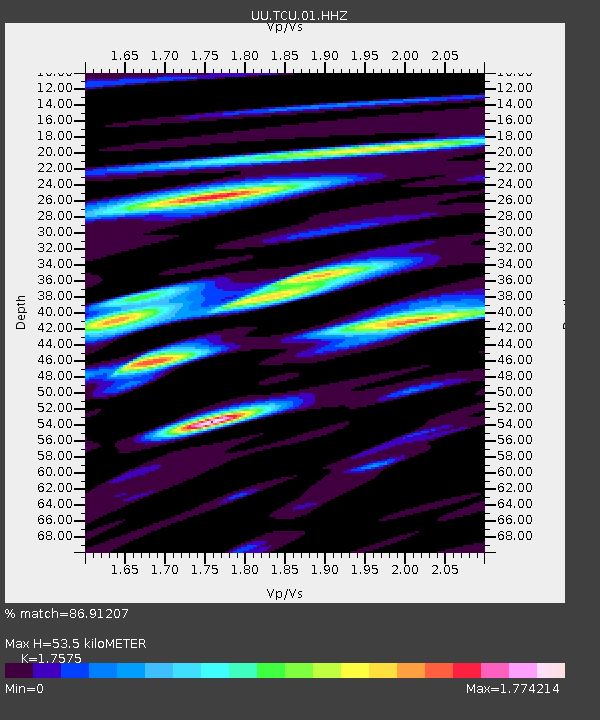
| Estimated Moho Depth: |
53.5 km |
| Estimated Crust Vp/Vs: |
1.76 |
| Assumed Crust Vp: |
6.155 km/s |
| Estimated Crust Vs: |
3.502 km/s |
| Estimated Crust Poisson's Ratio: |
0.26 |
|
| Radial Match: |
86.91207 % |
| Radial Bump: |
400 |
| Transverse Match: |
78.480225 % |
| Transverse Bump: |
400 |
| SOD ConfigId: |
30536071 |
| Insert Time: |
2023-05-12 03:40:18.285 +0000 |
| GWidth: |
2.5 |
| Max Bumps: |
400 |
| Tol: |
0.001 |
|

Signal To Noise
| Channel | StoN | STA | LTA |
| UU:TCU:01:HHZ:20230428T03:25:22.699992Z | 6.50323 | 6.3856163E-7 | 9.819145E-8 |
| UU:TCU:01:HHN:20230428T03:25:22.699992Z | 3.2639973 | 2.8733567E-7 | 8.803183E-8 |
| UU:TCU:01:HHE:20230428T03:25:22.699992Z | 2.3772469 | 2.8876892E-7 | 1.21472E-7 |
| Arrivals |
| Ps | 6.7 SECOND |
| PpPs | 24 SECOND |
| PsPs/PpSs | 30 SECOND |


