You are here: Home > Network List > IW - Intermountain West Stations List
> Station IMW Indian Meadow, Wyoming, USA > Earthquake Result Viewer
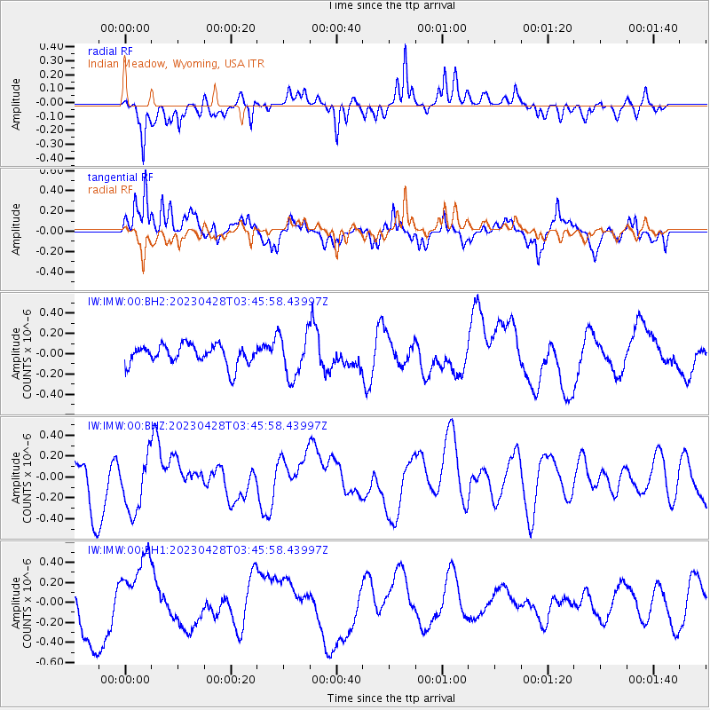
IMW Indian Meadow, Wyoming, USA - Earthquake Result Viewer
*The percent match for this event was below the threshold and hence no stack was calculated.
| Earthquake location: |
South Of Fiji Islands |
| Earthquake latitude/longitude: |
-25.1/178.4 |
| Earthquake time(UTC): |
2023/04/28 (118) 03:34:10 GMT |
| Earthquake Depth: |
570 km |
| Earthquake Magnitude: |
5.5 Mww |
| Earthquake Catalog/Contributor: |
NEIC PDE/us |
|
| Network: |
IW Intermountain West |
| Station: |
IMW Indian Meadow, Wyoming, USA |
| Lat/Lon: |
43.90 N/110.94 W |
| Elevation: |
2646 m |
|
| Distance: |
94.3 deg |
| Az: |
43.165 deg |
| Baz: |
239.086 deg |
| Ray Param: |
$rayparam |
*The percent match for this event was below the threshold and hence was not used in the summary stack. |
|
| Radial Match: |
61.658176 % |
| Radial Bump: |
400 |
| Transverse Match: |
70.55939 % |
| Transverse Bump: |
400 |
| SOD ConfigId: |
30536071 |
| Insert Time: |
2023-05-12 03:53:06.231 +0000 |
| GWidth: |
2.5 |
| Max Bumps: |
400 |
| Tol: |
0.001 |
|
Signal To Noise
| Channel | StoN | STA | LTA |
| IW:IMW:00:BHZ:20230428T03:45:58.43997Z | 1.5460323 | 2.7420595E-7 | 1.7736106E-7 |
| IW:IMW:00:BH1:20230428T03:45:58.43997Z | 1.7009131 | 3.6669317E-7 | 2.1558607E-7 |
| IW:IMW:00:BH2:20230428T03:45:58.43997Z | 2.132235 | 2.1034025E-7 | 9.864778E-8 |
| Arrivals |
| Ps | |
| PpPs | |
| PsPs/PpSs | |


