You are here: Home > Network List > TA - USArray Transportable Network (new EarthScope stations) Stations List
> Station X18A Snowflake, AZ, USA > Earthquake Result Viewer
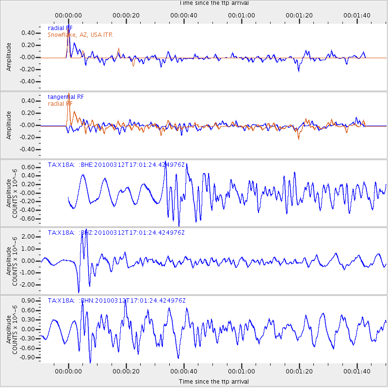
X18A Snowflake, AZ, USA - Earthquake Result Viewer
*The percent match for this event was below the threshold and hence no stack was calculated.
| Earthquake location: |
Near Coast Of Central Chile |
| Earthquake latitude/longitude: |
-34.2/-71.9 |
| Earthquake time(UTC): |
2010/03/12 (071) 16:50:01 GMT |
| Earthquake Depth: |
7.0 km |
| Earthquake Magnitude: |
6.1 MB, 5.4 MS, 5.8 MW, 5.7 MW |
| Earthquake Catalog/Contributor: |
WHDF/NEIC |
|
| Network: |
TA USArray Transportable Network (new EarthScope stations) |
| Station: |
X18A Snowflake, AZ, USA |
| Lat/Lon: |
34.53 N/109.95 W |
| Elevation: |
1751 m |
|
| Distance: |
77.1 deg |
| Az: |
328.548 deg |
| Baz: |
148.425 deg |
| Ray Param: |
$rayparam |
*The percent match for this event was below the threshold and hence was not used in the summary stack. |
|
| Radial Match: |
71.94742 % |
| Radial Bump: |
371 |
| Transverse Match: |
53.466732 % |
| Transverse Bump: |
375 |
| SOD ConfigId: |
308276 |
| Insert Time: |
2010-06-22 17:50:26.245 +0000 |
| GWidth: |
2.5 |
| Max Bumps: |
400 |
| Tol: |
0.001 |
|
Signal To Noise
| Channel | StoN | STA | LTA |
| TA:X18A: :BHZ:20100312T17:01:24.424976Z | 5.2223616 | 1.0592322E-6 | 2.028263E-7 |
| TA:X18A: :BHN:20100312T17:01:24.424976Z | 2.294133 | 3.5735897E-7 | 1.5577082E-7 |
| TA:X18A: :BHE:20100312T17:01:24.424976Z | 1.5022429 | 3.1155653E-7 | 2.0739425E-7 |
| Arrivals |
| Ps | |
| PpPs | |
| PsPs/PpSs | |


