You are here: Home > Network List > TA - USArray Transportable Network (new EarthScope stations) Stations List
> Station O24A Longmont, CO, USA > Earthquake Result Viewer
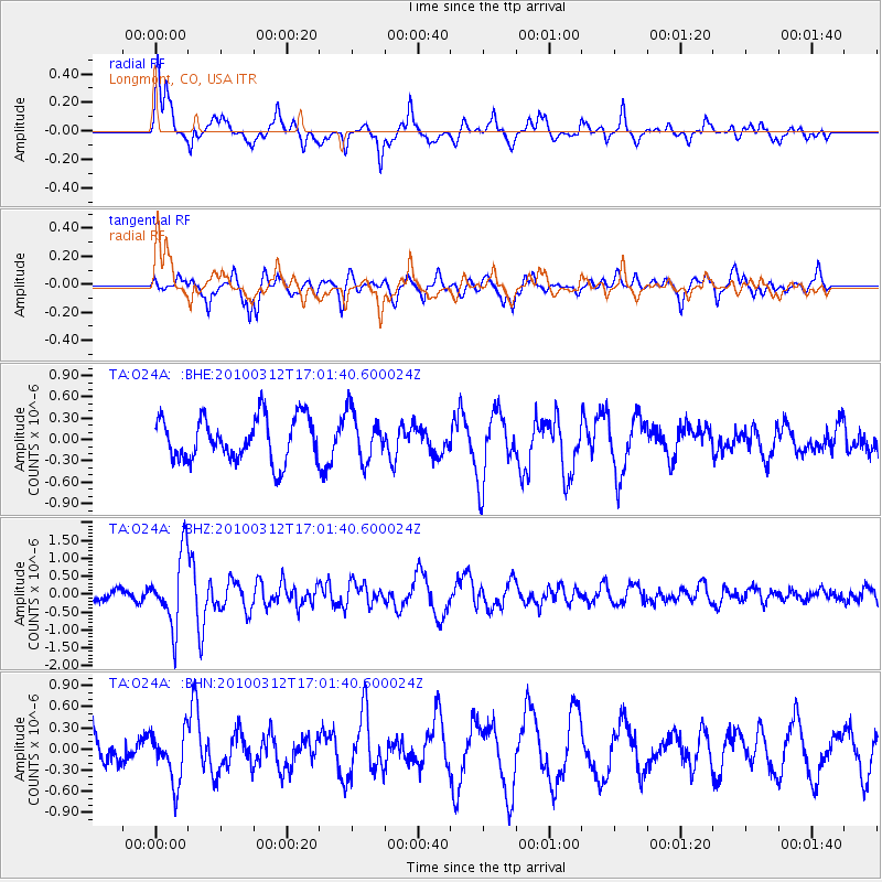
O24A Longmont, CO, USA - Earthquake Result Viewer
*The percent match for this event was below the threshold and hence no stack was calculated.
| Earthquake location: |
Near Coast Of Central Chile |
| Earthquake latitude/longitude: |
-34.2/-71.9 |
| Earthquake time(UTC): |
2010/03/12 (071) 16:50:01 GMT |
| Earthquake Depth: |
7.0 km |
| Earthquake Magnitude: |
6.1 MB, 5.4 MS, 5.8 MW, 5.7 MW |
| Earthquake Catalog/Contributor: |
WHDF/NEIC |
|
| Network: |
TA USArray Transportable Network (new EarthScope stations) |
| Station: |
O24A Longmont, CO, USA |
| Lat/Lon: |
40.12 N/105.07 W |
| Elevation: |
1553 m |
|
| Distance: |
80.1 deg |
| Az: |
334.802 deg |
| Baz: |
152.612 deg |
| Ray Param: |
$rayparam |
*The percent match for this event was below the threshold and hence was not used in the summary stack. |
|
| Radial Match: |
69.3266 % |
| Radial Bump: |
400 |
| Transverse Match: |
70.105965 % |
| Transverse Bump: |
400 |
| SOD ConfigId: |
308276 |
| Insert Time: |
2010-06-22 17:55:02.137 +0000 |
| GWidth: |
2.5 |
| Max Bumps: |
400 |
| Tol: |
0.001 |
|
Signal To Noise
| Channel | StoN | STA | LTA |
| TA:O24A: :BHZ:20100312T17:01:40.600024Z | 5.3471775 | 9.889575E-7 | 1.8494944E-7 |
| TA:O24A: :BHN:20100312T17:01:40.600024Z | 1.4121411 | 3.687819E-7 | 2.611509E-7 |
| TA:O24A: :BHE:20100312T17:01:40.600024Z | 1.1166987 | 3.4043933E-7 | 3.0486228E-7 |
| Arrivals |
| Ps | |
| PpPs | |
| PsPs/PpSs | |


