You are here: Home > Network List > TM - Thai Seismic Monitoring Network Stations List
> Station CHBT Khereethan Dam, Chanthaburi > Earthquake Result Viewer
CHBT Khereethan Dam, Chanthaburi - Earthquake Result Viewer
| Earthquake location: |
Irian Jaya Region, Indonesia |
| Earthquake latitude/longitude: |
-4.9/133.9 |
| Earthquake time(UTC): |
2023/04/28 (118) 18:12:51 GMT |
| Earthquake Depth: |
10 km |
| Earthquake Magnitude: |
5.5 Mww |
| Earthquake Catalog/Contributor: |
NEIC PDE/us |
|
| Network: |
TM Thai Seismic Monitoring Network |
| Station: |
CHBT Khereethan Dam, Chanthaburi |
| Lat/Lon: |
12.74 N/102.35 E |
| Elevation: |
198 m |
|
| Distance: |
35.9 deg |
| Az: |
299.434 deg |
| Baz: |
117.193 deg |
| Ray Param: |
0.07698303 |
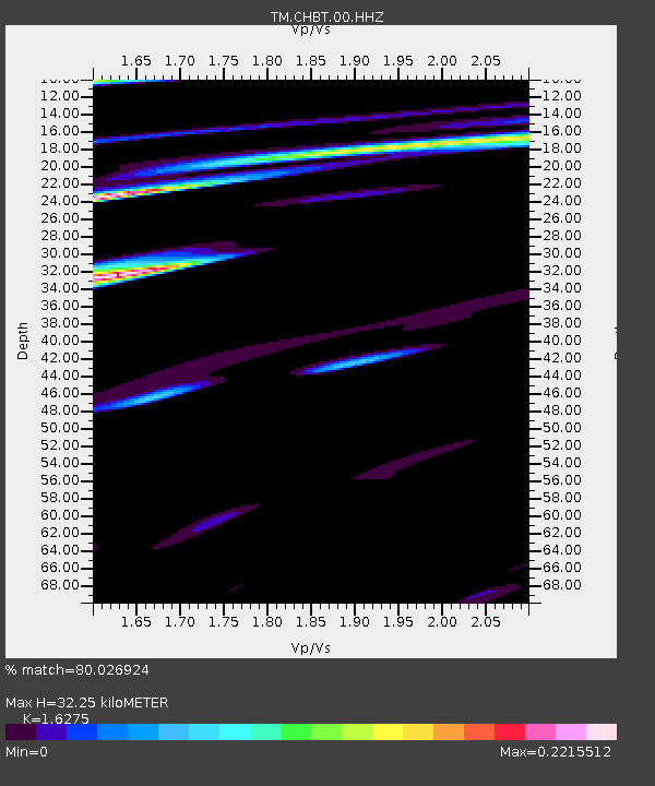
| Estimated Moho Depth: |
32.25 km |
| Estimated Crust Vp/Vs: |
1.63 |
| Assumed Crust Vp: |
6.498 km/s |
| Estimated Crust Vs: |
3.992 km/s |
| Estimated Crust Poisson's Ratio: |
0.20 |
|
| Radial Match: |
80.026924 % |
| Radial Bump: |
400 |
| Transverse Match: |
40.42094 % |
| Transverse Bump: |
400 |
| SOD ConfigId: |
30536071 |
| Insert Time: |
2023-05-12 18:20:00.081 +0000 |
| GWidth: |
2.5 |
| Max Bumps: |
400 |
| Tol: |
0.001 |
|

Signal To Noise
| Channel | StoN | STA | LTA |
| TM:CHBT:00:HHZ:20230428T18:19:20.649987Z | 3.096832 | 1.3963623E-7 | 4.5090022E-8 |
| TM:CHBT:00:HHN:20230428T18:19:20.649987Z | 0.6961897 | 7.181285E-8 | 1.03151265E-7 |
| TM:CHBT:00:HHE:20230428T18:19:20.649987Z | 1.4321262 | 8.110676E-8 | 5.6633812E-8 |
| Arrivals |
| Ps | 3.4 SECOND |
| PpPs | 12 SECOND |
| PsPs/PpSs | 15 SECOND |


