You are here: Home > Network List > IU - Global Seismograph Network (GSN - IRIS/USGS) Stations List
> Station PMG Port Moresby, New Guinea > Earthquake Result Viewer
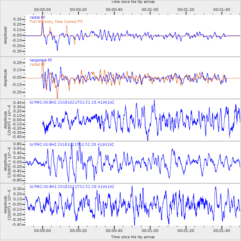
PMG Port Moresby, New Guinea - Earthquake Result Viewer
*The percent match for this event was below the threshold and hence no stack was calculated.
| Earthquake location: |
Southwest Indian Ridge |
| Earthquake latitude/longitude: |
-29.5/60.7 |
| Earthquake time(UTC): |
2018/10/21 (294) 01:40:37 GMT |
| Earthquake Depth: |
10 km |
| Earthquake Magnitude: |
5.9 Mww |
| Earthquake Catalog/Contributor: |
NEIC PDE/us |
|
| Network: |
IU Global Seismograph Network (GSN - IRIS/USGS) |
| Station: |
PMG Port Moresby, New Guinea |
| Lat/Lon: |
9.40 S/147.16 E |
| Elevation: |
90 m |
|
| Distance: |
82.4 deg |
| Az: |
96.465 deg |
| Baz: |
241.36 deg |
| Ray Param: |
$rayparam |
*The percent match for this event was below the threshold and hence was not used in the summary stack. |
|
| Radial Match: |
73.23466 % |
| Radial Bump: |
400 |
| Transverse Match: |
47.969173 % |
| Transverse Bump: |
400 |
| SOD ConfigId: |
3045211 |
| Insert Time: |
2018-11-04 01:57:47.960 +0000 |
| GWidth: |
2.5 |
| Max Bumps: |
400 |
| Tol: |
0.001 |
|
Signal To Noise
| Channel | StoN | STA | LTA |
| IU:PMG:00:BHZ:20181021T01:52:28.419019Z | 1.8874334 | 2.3945975E-7 | 1.2687057E-7 |
| IU:PMG:00:BH1:20181021T01:52:28.419019Z | 1.0440283 | 1.03319216E-7 | 9.896208E-8 |
| IU:PMG:00:BH2:20181021T01:52:28.419019Z | 1.0251366 | 1.0790228E-7 | 1.052565E-7 |
| Arrivals |
| Ps | |
| PpPs | |
| PsPs/PpSs | |


