You are here: Home > Network List > AK - Alaska Regional Network Stations List
> Station D20K Etivluk River, AK, USA > Earthquake Result Viewer
D20K Etivluk River, AK, USA - Earthquake Result Viewer
| Earthquake location: |
Ryukyu Islands, Japan |
| Earthquake latitude/longitude: |
26.0/128.6 |
| Earthquake time(UTC): |
2023/05/01 (121) 03:22:09 GMT |
| Earthquake Depth: |
11 km |
| Earthquake Magnitude: |
5.9 mww |
| Earthquake Catalog/Contributor: |
NEIC PDE/us |
|
| Network: |
AK Alaska Regional Network |
| Station: |
D20K Etivluk River, AK, USA |
| Lat/Lon: |
68.71 N/156.61 W |
| Elevation: |
577 m |
|
| Distance: |
60.5 deg |
| Az: |
23.879 deg |
| Baz: |
266.024 deg |
| Ray Param: |
0.061490126 |
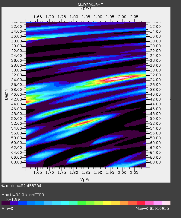
| Estimated Moho Depth: |
33.0 km |
| Estimated Crust Vp/Vs: |
1.99 |
| Assumed Crust Vp: |
6.221 km/s |
| Estimated Crust Vs: |
3.126 km/s |
| Estimated Crust Poisson's Ratio: |
0.33 |
|
| Radial Match: |
82.455734 % |
| Radial Bump: |
400 |
| Transverse Match: |
83.04689 % |
| Transverse Bump: |
400 |
| SOD ConfigId: |
30536071 |
| Insert Time: |
2023-05-15 03:25:09.475 +0000 |
| GWidth: |
2.5 |
| Max Bumps: |
400 |
| Tol: |
0.001 |
|

Signal To Noise
| Channel | StoN | STA | LTA |
| AK:D20K: :BHZ:20230501T03:31:48.879971Z | 5.294018 | 6.2142806E-7 | 1.1738307E-7 |
| AK:D20K: :BHN:20230501T03:31:48.879971Z | 1.514241 | 1.9650342E-7 | 1.2977023E-7 |
| AK:D20K: :BHE:20230501T03:31:48.879971Z | 2.3628662 | 2.6917678E-7 | 1.1391961E-7 |
| Arrivals |
| Ps | 5.5 SECOND |
| PpPs | 15 SECOND |
| PsPs/PpSs | 21 SECOND |


