You are here: Home > Network List > TA - USArray Transportable Network (new EarthScope stations) Stations List
> Station I22A 9 Mile Ranch, Kaycee, WY, USA > Earthquake Result Viewer
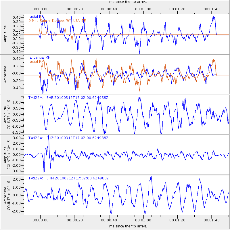
I22A 9 Mile Ranch, Kaycee, WY, USA - Earthquake Result Viewer
*The percent match for this event was below the threshold and hence no stack was calculated.
| Earthquake location: |
Near Coast Of Central Chile |
| Earthquake latitude/longitude: |
-34.2/-71.9 |
| Earthquake time(UTC): |
2010/03/12 (071) 16:50:01 GMT |
| Earthquake Depth: |
7.0 km |
| Earthquake Magnitude: |
6.1 MB, 5.4 MS, 5.8 MW, 5.7 MW |
| Earthquake Catalog/Contributor: |
WHDF/NEIC |
|
| Network: |
TA USArray Transportable Network (new EarthScope stations) |
| Station: |
I22A 9 Mile Ranch, Kaycee, WY, USA |
| Lat/Lon: |
43.89 N/106.48 W |
| Elevation: |
1430 m |
|
| Distance: |
83.9 deg |
| Az: |
335.636 deg |
| Baz: |
151.787 deg |
| Ray Param: |
$rayparam |
*The percent match for this event was below the threshold and hence was not used in the summary stack. |
|
| Radial Match: |
59.5423 % |
| Radial Bump: |
400 |
| Transverse Match: |
56.267097 % |
| Transverse Bump: |
350 |
| SOD ConfigId: |
308276 |
| Insert Time: |
2010-06-22 17:59:44.861 +0000 |
| GWidth: |
2.5 |
| Max Bumps: |
400 |
| Tol: |
0.001 |
|
Signal To Noise
| Channel | StoN | STA | LTA |
| TA:I22A: :BHZ:20100312T17:02:00.624988Z | 5.758819 | 1.4265491E-6 | 2.4771558E-7 |
| TA:I22A: :BHN:20100312T17:02:00.624988Z | 0.41558102 | 2.0818162E-7 | 5.009411E-7 |
| TA:I22A: :BHE:20100312T17:02:00.624988Z | 1.3185096 | 9.014697E-7 | 6.837036E-7 |
| Arrivals |
| Ps | |
| PpPs | |
| PsPs/PpSs | |


