You are here: Home > Network List > TA - USArray Transportable Network (new EarthScope stations) Stations List
> Station S26A Kim, CO, USA > Earthquake Result Viewer
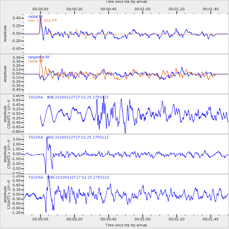
S26A Kim, CO, USA - Earthquake Result Viewer
*The percent match for this event was below the threshold and hence no stack was calculated.
| Earthquake location: |
Near Coast Of Central Chile |
| Earthquake latitude/longitude: |
-34.2/-71.9 |
| Earthquake time(UTC): |
2010/03/12 (071) 16:50:01 GMT |
| Earthquake Depth: |
7.0 km |
| Earthquake Magnitude: |
6.1 MB, 5.4 MS, 5.8 MW, 5.7 MW |
| Earthquake Catalog/Contributor: |
WHDF/NEIC |
|
| Network: |
TA USArray Transportable Network (new EarthScope stations) |
| Station: |
S26A Kim, CO, USA |
| Lat/Lon: |
37.62 N/103.47 W |
| Elevation: |
1394 m |
|
| Distance: |
77.3 deg |
| Az: |
334.787 deg |
| Baz: |
153.61 deg |
| Ray Param: |
$rayparam |
*The percent match for this event was below the threshold and hence was not used in the summary stack. |
|
| Radial Match: |
77.00589 % |
| Radial Bump: |
400 |
| Transverse Match: |
63.20553 % |
| Transverse Bump: |
400 |
| SOD ConfigId: |
308276 |
| Insert Time: |
2010-06-22 18:02:41.002 +0000 |
| GWidth: |
2.5 |
| Max Bumps: |
400 |
| Tol: |
0.001 |
|
Signal To Noise
| Channel | StoN | STA | LTA |
| TA:S26A: :BHZ:20100312T17:01:25.275012Z | 6.8711457 | 1.4802876E-6 | 2.1543534E-7 |
| TA:S26A: :BHN:20100312T17:01:25.275012Z | 3.2095957 | 5.1051484E-7 | 1.5905893E-7 |
| TA:S26A: :BHE:20100312T17:01:25.275012Z | 1.3466612 | 2.9586474E-7 | 2.1970244E-7 |
| Arrivals |
| Ps | |
| PpPs | |
| PsPs/PpSs | |


