You are here: Home > Network List > TA - USArray Transportable Network (new EarthScope stations) Stations List
> Station R27A Eads, CO, USA > Earthquake Result Viewer
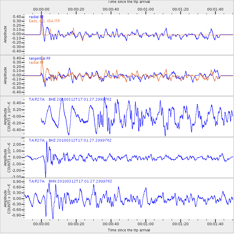
R27A Eads, CO, USA - Earthquake Result Viewer
*The percent match for this event was below the threshold and hence no stack was calculated.
| Earthquake location: |
Near Coast Of Central Chile |
| Earthquake latitude/longitude: |
-34.2/-71.9 |
| Earthquake time(UTC): |
2010/03/12 (071) 16:50:01 GMT |
| Earthquake Depth: |
7.0 km |
| Earthquake Magnitude: |
6.1 MB, 5.4 MS, 5.8 MW, 5.7 MW |
| Earthquake Catalog/Contributor: |
WHDF/NEIC |
|
| Network: |
TA USArray Transportable Network (new EarthScope stations) |
| Station: |
R27A Eads, CO, USA |
| Lat/Lon: |
38.29 N/102.80 W |
| Elevation: |
1201 m |
|
| Distance: |
77.6 deg |
| Az: |
335.576 deg |
| Baz: |
154.194 deg |
| Ray Param: |
$rayparam |
*The percent match for this event was below the threshold and hence was not used in the summary stack. |
|
| Radial Match: |
59.20889 % |
| Radial Bump: |
400 |
| Transverse Match: |
74.89463 % |
| Transverse Bump: |
400 |
| SOD ConfigId: |
308276 |
| Insert Time: |
2010-06-22 18:03:07.152 +0000 |
| GWidth: |
2.5 |
| Max Bumps: |
400 |
| Tol: |
0.001 |
|
Signal To Noise
| Channel | StoN | STA | LTA |
| TA:R27A: :BHZ:20100312T17:01:27.299976Z | 5.1474533 | 1.0987229E-6 | 2.1344981E-7 |
| TA:R27A: :BHN:20100312T17:01:27.299976Z | 1.8940605 | 4.139086E-7 | 2.1852976E-7 |
| TA:R27A: :BHE:20100312T17:01:27.299976Z | 1.0597248 | 2.4920982E-7 | 2.3516465E-7 |
| Arrivals |
| Ps | |
| PpPs | |
| PsPs/PpSs | |


