You are here: Home > Network List > TA - USArray Transportable Network (new EarthScope stations) Stations List
> Station V29A Stinnett, TX, USA > Earthquake Result Viewer
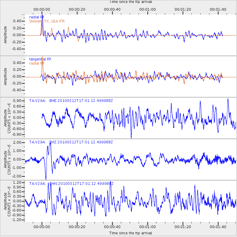
V29A Stinnett, TX, USA - Earthquake Result Viewer
*The percent match for this event was below the threshold and hence no stack was calculated.
| Earthquake location: |
Near Coast Of Central Chile |
| Earthquake latitude/longitude: |
-34.2/-71.9 |
| Earthquake time(UTC): |
2010/03/12 (071) 16:50:01 GMT |
| Earthquake Depth: |
7.0 km |
| Earthquake Magnitude: |
6.1 MB, 5.4 MS, 5.8 MW, 5.7 MW |
| Earthquake Catalog/Contributor: |
WHDF/NEIC |
|
| Network: |
TA USArray Transportable Network (new EarthScope stations) |
| Station: |
V29A Stinnett, TX, USA |
| Lat/Lon: |
35.87 N/101.52 W |
| Elevation: |
953 m |
|
| Distance: |
75.0 deg |
| Az: |
335.461 deg |
| Baz: |
154.934 deg |
| Ray Param: |
$rayparam |
*The percent match for this event was below the threshold and hence was not used in the summary stack. |
|
| Radial Match: |
66.09806 % |
| Radial Bump: |
400 |
| Transverse Match: |
57.58876 % |
| Transverse Bump: |
400 |
| SOD ConfigId: |
308276 |
| Insert Time: |
2010-06-22 18:03:32.486 +0000 |
| GWidth: |
2.5 |
| Max Bumps: |
400 |
| Tol: |
0.001 |
|
Signal To Noise
| Channel | StoN | STA | LTA |
| TA:V29A: :BHZ:20100312T17:01:12.499988Z | 4.6732473 | 1.1108572E-6 | 2.3770563E-7 |
| TA:V29A: :BHN:20100312T17:01:12.499988Z | 2.2048612 | 4.343511E-7 | 1.9699702E-7 |
| TA:V29A: :BHE:20100312T17:01:12.499988Z | 0.45549762 | 1.2001915E-7 | 2.6349016E-7 |
| Arrivals |
| Ps | |
| PpPs | |
| PsPs/PpSs | |


