You are here: Home > Network List > ET - CERI Southern Appalachian seismic Network Stations List
> Station FPAL Fort Payne,AL > Earthquake Result Viewer
FPAL Fort Payne,AL - Earthquake Result Viewer
| Earthquake location: |
Vancouver Island, Canada Region |
| Earthquake latitude/longitude: |
49.1/-129.7 |
| Earthquake time(UTC): |
2018/10/22 (295) 05:39:39 GMT |
| Earthquake Depth: |
11 km |
| Earthquake Magnitude: |
6.6 Mi |
| Earthquake Catalog/Contributor: |
NEIC PDE/at |
|
| Network: |
ET CERI Southern Appalachian seismic Network |
| Station: |
FPAL Fort Payne,AL |
| Lat/Lon: |
34.54 N/85.61 W |
| Elevation: |
556 m |
|
| Distance: |
35.4 deg |
| Az: |
97.547 deg |
| Baz: |
307.936 deg |
| Ray Param: |
0.0772223 |
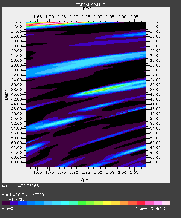
| Estimated Moho Depth: |
10.0 km |
| Estimated Crust Vp/Vs: |
1.77 |
| Assumed Crust Vp: |
6.35 km/s |
| Estimated Crust Vs: |
3.583 km/s |
| Estimated Crust Poisson's Ratio: |
0.27 |
|
| Radial Match: |
88.26166 % |
| Radial Bump: |
195 |
| Transverse Match: |
56.489933 % |
| Transverse Bump: |
377 |
| SOD ConfigId: |
3045211 |
| Insert Time: |
2018-11-05 05:45:44.578 +0000 |
| GWidth: |
2.5 |
| Max Bumps: |
400 |
| Tol: |
0.001 |
|

Signal To Noise
| Channel | StoN | STA | LTA |
| ET:FPAL:00:HHZ:20181022T05:46:04.285004Z | 5.214847 | 6.5471386E-7 | 1.2554804E-7 |
| ET:FPAL:00:HHN:20181022T05:46:04.285004Z | 2.263118 | 2.3662649E-7 | 1.04557735E-7 |
| ET:FPAL:00:HHE:20181022T05:46:04.285004Z | 2.1907349 | 2.9953455E-7 | 1.3672789E-7 |
| Arrivals |
| Ps | 1.3 SECOND |
| PpPs | 4.1 SECOND |
| PsPs/PpSs | 5.4 SECOND |


