You are here: Home > Network List > TA - USArray Transportable Network (new EarthScope stations) Stations List
> Station 532A Rocksprings, TX, USA > Earthquake Result Viewer
532A Rocksprings, TX, USA - Earthquake Result Viewer
| Earthquake location: |
Near Coast Of Central Chile |
| Earthquake latitude/longitude: |
-34.2/-71.9 |
| Earthquake time(UTC): |
2010/03/12 (071) 16:50:01 GMT |
| Earthquake Depth: |
7.0 km |
| Earthquake Magnitude: |
6.1 MB, 5.4 MS, 5.8 MW, 5.7 MW |
| Earthquake Catalog/Contributor: |
WHDF/NEIC |
|
| Network: |
TA USArray Transportable Network (new EarthScope stations) |
| Station: |
532A Rocksprings, TX, USA |
| Lat/Lon: |
30.13 N/99.90 W |
| Elevation: |
703 m |
|
| Distance: |
69.3 deg |
| Az: |
334.23 deg |
| Baz: |
155.433 deg |
| Ray Param: |
0.055773936 |
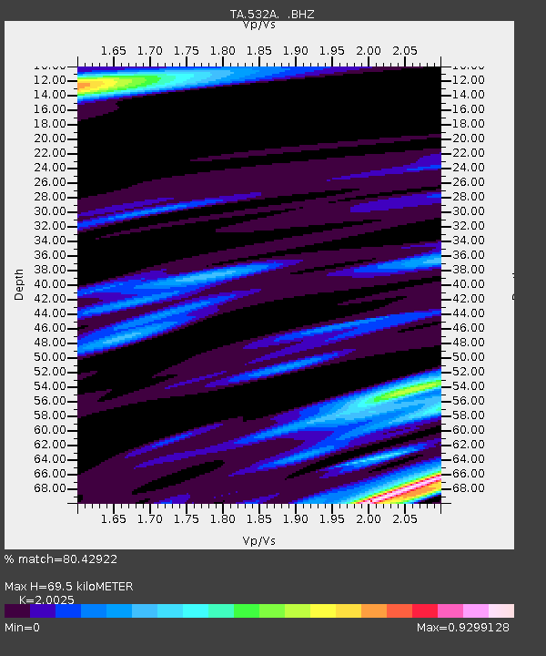
| Estimated Moho Depth: |
69.5 km |
| Estimated Crust Vp/Vs: |
2.00 |
| Assumed Crust Vp: |
6.498 km/s |
| Estimated Crust Vs: |
3.245 km/s |
| Estimated Crust Poisson's Ratio: |
0.33 |
|
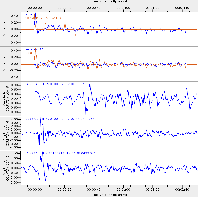
| Radial Match: |
80.42922 % |
| Radial Bump: |
400 |
| Transverse Match: |
75.60012 % |
| Transverse Bump: |
400 |
| SOD ConfigId: |
308276 |
| Insert Time: |
2010-06-22 18:05:38.513 +0000 |
| GWidth: |
2.5 |
| Max Bumps: |
400 |
| Tol: |
0.001 |
|
Signal To Noise
| Channel | StoN | STA | LTA |
| TA:532A: :BHZ:20100312T17:00:38.049976Z | 6.1736555 | 1.7521702E-6 | 2.8381405E-7 |
| TA:532A: :BHN:20100312T17:00:38.049976Z | 4.450283 | 6.785821E-7 | 1.5248067E-7 |
| TA:532A: :BHE:20100312T17:00:38.049976Z | 1.7684207 | 3.951403E-7 | 2.2344247E-7 |
| Arrivals |
| Ps | 11 SECOND |
| PpPs | 31 SECOND |
| PsPs/PpSs | 42 SECOND |


