You are here: Home > Network List > US - United States National Seismic Network Stations List
> Station CBKS Cedar Bluff, Kansas, USA > Earthquake Result Viewer
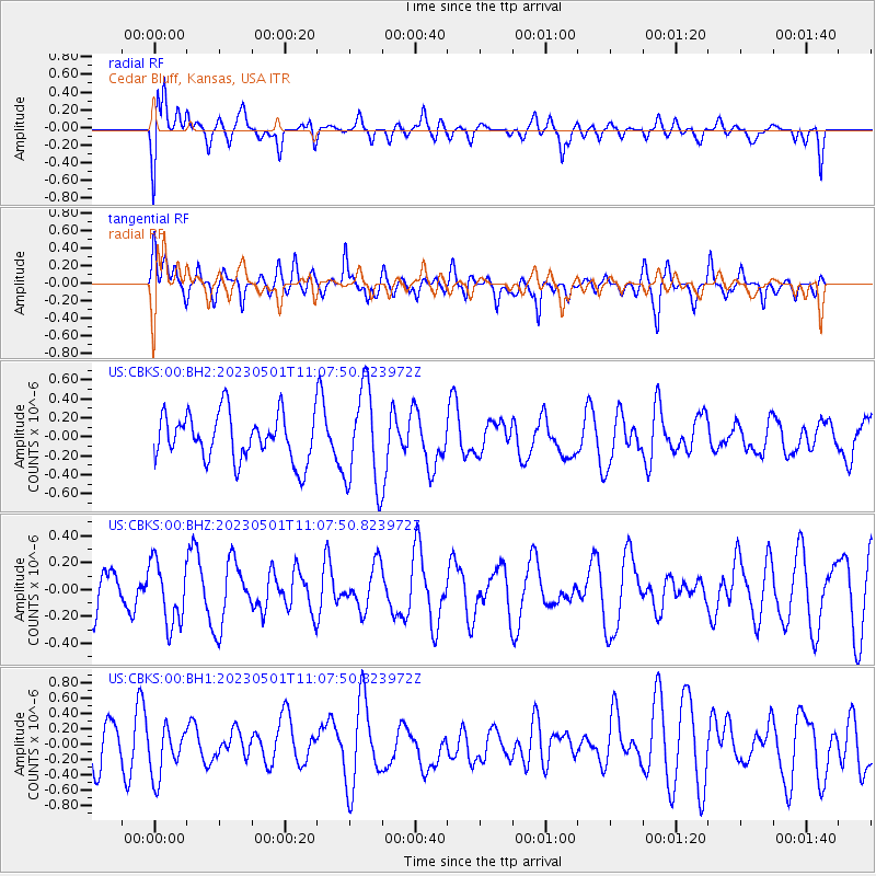
CBKS Cedar Bluff, Kansas, USA - Earthquake Result Viewer
*The percent match for this event was below the threshold and hence no stack was calculated.
| Earthquake location: |
South Of Fiji Islands |
| Earthquake latitude/longitude: |
-22.1/-179.4 |
| Earthquake time(UTC): |
2023/05/01 (121) 10:55:55 GMT |
| Earthquake Depth: |
570 km |
| Earthquake Magnitude: |
5.6 Mww |
| Earthquake Catalog/Contributor: |
NEIC PDE/us |
|
| Network: |
US United States National Seismic Network |
| Station: |
CBKS Cedar Bluff, Kansas, USA |
| Lat/Lon: |
38.81 N/99.74 W |
| Elevation: |
677 m |
|
| Distance: |
96.0 deg |
| Az: |
50.608 deg |
| Baz: |
246.514 deg |
| Ray Param: |
$rayparam |
*The percent match for this event was below the threshold and hence was not used in the summary stack. |
|
| Radial Match: |
51.554497 % |
| Radial Bump: |
400 |
| Transverse Match: |
56.732834 % |
| Transverse Bump: |
400 |
| SOD ConfigId: |
30536071 |
| Insert Time: |
2023-05-15 11:13:50.294 +0000 |
| GWidth: |
2.5 |
| Max Bumps: |
400 |
| Tol: |
0.001 |
|
Signal To Noise
| Channel | StoN | STA | LTA |
| US:CBKS:00:BHZ:20230501T11:07:50.823972Z | 1.245996 | 2.317649E-7 | 1.8600775E-7 |
| US:CBKS:00:BH1:20230501T11:07:50.823972Z | 0.78088796 | 3.1436488E-7 | 4.0257362E-7 |
| US:CBKS:00:BH2:20230501T11:07:50.823972Z | 2.0923157 | 5.1659504E-7 | 2.469011E-7 |
| Arrivals |
| Ps | |
| PpPs | |
| PsPs/PpSs | |


