You are here: Home > Network List > CN - Canadian National Seismograph Network Stations List
> Station INK INUVIK, NT > Earthquake Result Viewer
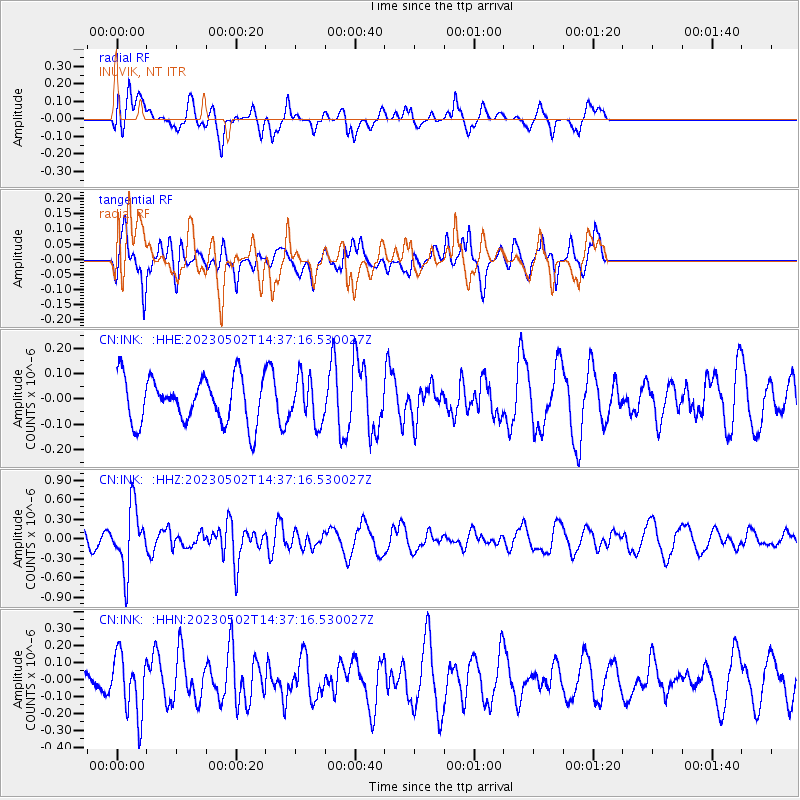
INK INUVIK, NT - Earthquake Result Viewer
*The percent match for this event was below the threshold and hence no stack was calculated.
| Earthquake location: |
Samoa Islands Region |
| Earthquake latitude/longitude: |
-15.7/-172.5 |
| Earthquake time(UTC): |
2023/05/02 (122) 14:24:59 GMT |
| Earthquake Depth: |
35 km |
| Earthquake Magnitude: |
5.5 mww |
| Earthquake Catalog/Contributor: |
NEIC PDE/us |
|
| Network: |
CN Canadian National Seismograph Network |
| Station: |
INK INUVIK, NT |
| Lat/Lon: |
68.31 N/133.53 W |
| Elevation: |
44 m |
|
| Distance: |
88.3 deg |
| Az: |
13.543 deg |
| Baz: |
217.351 deg |
| Ray Param: |
$rayparam |
*The percent match for this event was below the threshold and hence was not used in the summary stack. |
|
| Radial Match: |
50.290462 % |
| Radial Bump: |
400 |
| Transverse Match: |
60.266666 % |
| Transverse Bump: |
400 |
| SOD ConfigId: |
30536071 |
| Insert Time: |
2023-05-16 14:37:36.746 +0000 |
| GWidth: |
2.5 |
| Max Bumps: |
400 |
| Tol: |
0.001 |
|
Signal To Noise
| Channel | StoN | STA | LTA |
| CN:INK: :HHZ:20230502T14:37:16.530027Z | 2.810869 | 4.6813722E-7 | 1.6654536E-7 |
| CN:INK: :HHN:20230502T14:37:16.530027Z | 2.196113 | 1.7613456E-7 | 8.020286E-8 |
| CN:INK: :HHE:20230502T14:37:16.530027Z | 0.98397964 | 8.779858E-8 | 8.9228045E-8 |
| Arrivals |
| Ps | |
| PpPs | |
| PsPs/PpSs | |


