You are here: Home > Network List > IW - Intermountain West Stations List
> Station MOOW Moose Ponds, Wyoming, USA > Earthquake Result Viewer
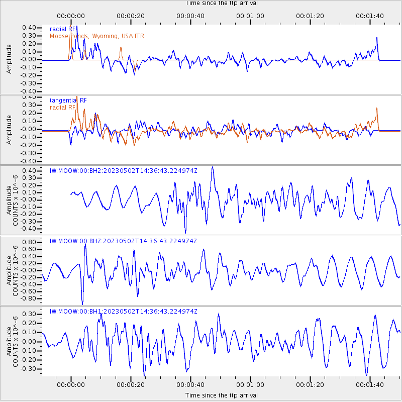
MOOW Moose Ponds, Wyoming, USA - Earthquake Result Viewer
*The percent match for this event was below the threshold and hence no stack was calculated.
| Earthquake location: |
Samoa Islands Region |
| Earthquake latitude/longitude: |
-15.7/-172.5 |
| Earthquake time(UTC): |
2023/05/02 (122) 14:24:59 GMT |
| Earthquake Depth: |
35 km |
| Earthquake Magnitude: |
5.5 mww |
| Earthquake Catalog/Contributor: |
NEIC PDE/us |
|
| Network: |
IW Intermountain West |
| Station: |
MOOW Moose Ponds, Wyoming, USA |
| Lat/Lon: |
43.75 N/110.74 W |
| Elevation: |
2128 m |
|
| Distance: |
81.7 deg |
| Az: |
40.202 deg |
| Baz: |
239.088 deg |
| Ray Param: |
$rayparam |
*The percent match for this event was below the threshold and hence was not used in the summary stack. |
|
| Radial Match: |
51.729214 % |
| Radial Bump: |
400 |
| Transverse Match: |
60.96715 % |
| Transverse Bump: |
400 |
| SOD ConfigId: |
30536071 |
| Insert Time: |
2023-05-16 14:40:54.250 +0000 |
| GWidth: |
2.5 |
| Max Bumps: |
400 |
| Tol: |
0.001 |
|
Signal To Noise
| Channel | StoN | STA | LTA |
| IW:MOOW:00:BHZ:20230502T14:36:43.224974Z | 3.4675744 | 3.5971385E-7 | 1.0373645E-7 |
| IW:MOOW:00:BH1:20230502T14:36:43.224974Z | 1.3641968 | 1.0177785E-7 | 7.460643E-8 |
| IW:MOOW:00:BH2:20230502T14:36:43.224974Z | 1.9863334 | 1.982151E-7 | 9.9789446E-8 |
| Arrivals |
| Ps | |
| PpPs | |
| PsPs/PpSs | |


