You are here: Home > Network List > GT - Global Telemetered Seismograph Network (USAF/USGS) Stations List
> Station LPAZ La Paz , Bolivia > Earthquake Result Viewer
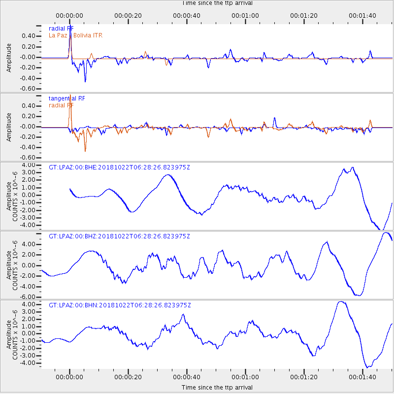
LPAZ La Paz , Bolivia - Earthquake Result Viewer

| Earthquake location: |
Vancouver Island, Canada Region |
| Earthquake latitude/longitude: |
49.1/-129.5 |
| Earthquake time(UTC): |
2018/10/22 (295) 06:16:26 GMT |
| Earthquake Depth: |
21 km |
| Earthquake Magnitude: |
6.8 Mi |
| Earthquake Catalog/Contributor: |
NEIC PDE/pt |
|
| Network: |
GT Global Telemetered Seismograph Network (USAF/USGS) |
| Station: |
LPAZ La Paz , Bolivia |
| Lat/Lon: |
16.17 S/68.08 W |
| Elevation: |
4817 m |
|
| Distance: |
84.6 deg |
| Az: |
122.053 deg |
| Baz: |
324.57 deg |
| Ray Param: |
0.045321476 |
| Estimated Moho Depth: |
11.0 km |
| Estimated Crust Vp/Vs: |
1.60 |
| Assumed Crust Vp: |
6.454 km/s |
| Estimated Crust Vs: |
4.034 km/s |
| Estimated Crust Poisson's Ratio: |
0.18 |
|
| Radial Match: |
85.75821 % |
| Radial Bump: |
395 |
| Transverse Match: |
36.42767 % |
| Transverse Bump: |
265 |
| SOD ConfigId: |
3045211 |
| Insert Time: |
2018-11-05 06:26:07.160 +0000 |
| GWidth: |
2.5 |
| Max Bumps: |
400 |
| Tol: |
0.001 |
|
Signal To Noise
| Channel | StoN | STA | LTA |
| GT:LPAZ:00:BHZ:20181022T06:28:26.823975Z | 0.6763103 | 1.1356095E-6 | 1.6791249E-6 |
| GT:LPAZ:00:BHN:20181022T06:28:26.823975Z | 0.49446267 | 6.720352E-7 | 1.3591222E-6 |
| GT:LPAZ:00:BHE:20181022T06:28:26.823975Z | 2.7863986 | 2.45226E-6 | 8.8008227E-7 |
| Arrivals |
| Ps | 1.1 SECOND |
| PpPs | 4.3 SECOND |
| PsPs/PpSs | 5.4 SECOND |


