You are here: Home > Network List > TX - Texas Seismological Network Stations List
> Station WTFS Witchita Falls > Earthquake Result Viewer
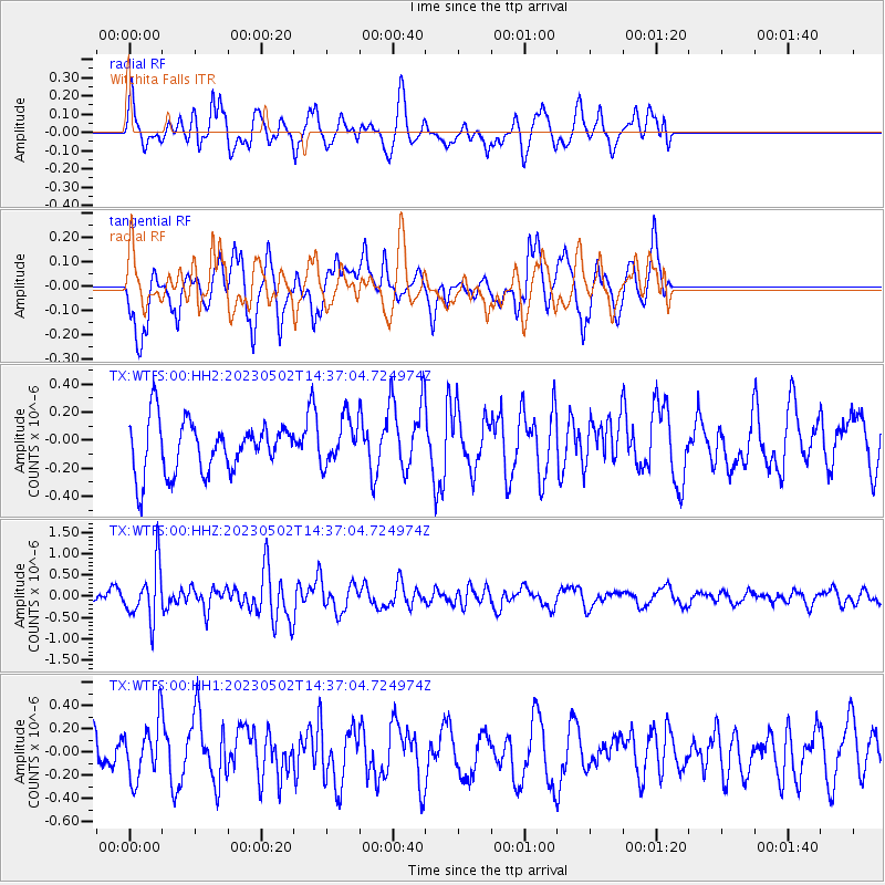
WTFS Witchita Falls - Earthquake Result Viewer
*The percent match for this event was below the threshold and hence no stack was calculated.
| Earthquake location: |
Samoa Islands Region |
| Earthquake latitude/longitude: |
-15.7/-172.5 |
| Earthquake time(UTC): |
2023/05/02 (122) 14:24:59 GMT |
| Earthquake Depth: |
35 km |
| Earthquake Magnitude: |
5.5 mww |
| Earthquake Catalog/Contributor: |
NEIC PDE/us |
|
| Network: |
TX Texas Seismological Network |
| Station: |
WTFS Witchita Falls |
| Lat/Lon: |
33.77 N/98.46 W |
| Elevation: |
277 m |
|
| Distance: |
85.9 deg |
| Az: |
53.431 deg |
| Baz: |
248.23 deg |
| Ray Param: |
$rayparam |
*The percent match for this event was below the threshold and hence was not used in the summary stack. |
|
| Radial Match: |
63.211586 % |
| Radial Bump: |
400 |
| Transverse Match: |
54.507 % |
| Transverse Bump: |
400 |
| SOD ConfigId: |
30536071 |
| Insert Time: |
2023-05-16 14:50:04.047 +0000 |
| GWidth: |
2.5 |
| Max Bumps: |
400 |
| Tol: |
0.001 |
|
Signal To Noise
| Channel | StoN | STA | LTA |
| TX:WTFS:00:HHZ:20230502T14:37:04.724974Z | 5.858942 | 6.3735007E-7 | 1.08782444E-7 |
| TX:WTFS:00:HH1:20230502T14:37:04.724974Z | 1.4836445 | 2.3574934E-7 | 1.588988E-7 |
| TX:WTFS:00:HH2:20230502T14:37:04.724974Z | 0.88697416 | 1.6182148E-7 | 1.8244215E-7 |
| Arrivals |
| Ps | |
| PpPs | |
| PsPs/PpSs | |


