You are here: Home > Network List > TA - USArray Transportable Network (new EarthScope stations) Stations List
> Station 833A Chaparral WMA, Artesia Wells, TX, USA > Earthquake Result Viewer
833A Chaparral WMA, Artesia Wells, TX, USA - Earthquake Result Viewer
| Earthquake location: |
Near Coast Of Central Chile |
| Earthquake latitude/longitude: |
-34.2/-71.9 |
| Earthquake time(UTC): |
2010/03/12 (071) 16:50:01 GMT |
| Earthquake Depth: |
7.0 km |
| Earthquake Magnitude: |
6.1 MB, 5.4 MS, 5.8 MW, 5.7 MW |
| Earthquake Catalog/Contributor: |
WHDF/NEIC |
|
| Network: |
TA USArray Transportable Network (new EarthScope stations) |
| Station: |
833A Chaparral WMA, Artesia Wells, TX, USA |
| Lat/Lon: |
28.32 N/99.39 W |
| Elevation: |
171 m |
|
| Distance: |
67.4 deg |
| Az: |
333.865 deg |
| Baz: |
155.546 deg |
| Ray Param: |
0.05696429 |
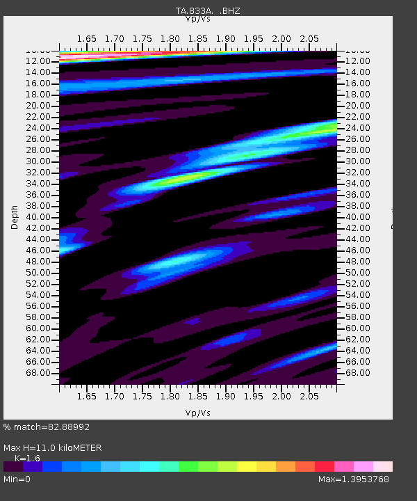
| Estimated Moho Depth: |
11.0 km |
| Estimated Crust Vp/Vs: |
1.60 |
| Assumed Crust Vp: |
6.347 km/s |
| Estimated Crust Vs: |
3.967 km/s |
| Estimated Crust Poisson's Ratio: |
0.18 |
|
| Radial Match: |
82.88992 % |
| Radial Bump: |
400 |
| Transverse Match: |
47.83745 % |
| Transverse Bump: |
400 |
| SOD ConfigId: |
308276 |
| Insert Time: |
2010-06-22 18:18:19.719 +0000 |
| GWidth: |
2.5 |
| Max Bumps: |
400 |
| Tol: |
0.001 |
|

Signal To Noise
| Channel | StoN | STA | LTA |
| TA:833A: :BHZ:20100312T17:00:26.674976Z | 11.630788 | 2.2404354E-6 | 1.9262973E-7 |
| TA:833A: :BHN:20100312T17:00:26.674976Z | 2.7059495 | 5.955348E-7 | 2.2008348E-7 |
| TA:833A: :BHE:20100312T17:00:26.674976Z | 0.9753653 | 2.5439775E-7 | 2.6082304E-7 |
| Arrivals |
| Ps | 1.1 SECOND |
| PpPs | 4.3 SECOND |
| PsPs/PpSs | 5.4 SECOND |


