You are here: Home > Network List > WY - Yellowstone Wyoming Seismic Network Stations List
> Station YUF Upper Falls, WY, USA > Earthquake Result Viewer
YUF Upper Falls, WY, USA - Earthquake Result Viewer
*The percent match for this event was below the threshold and hence no stack was calculated.
| Earthquake location: |
Samoa Islands Region |
| Earthquake latitude/longitude: |
-15.7/-172.5 |
| Earthquake time(UTC): |
2023/05/02 (122) 14:24:59 GMT |
| Earthquake Depth: |
35 km |
| Earthquake Magnitude: |
5.5 mww |
| Earthquake Catalog/Contributor: |
NEIC PDE/us |
|
| Network: |
WY Yellowstone Wyoming Seismic Network |
| Station: |
YUF Upper Falls, WY, USA |
| Lat/Lon: |
44.71 N/110.51 W |
| Elevation: |
2394 m |
|
| Distance: |
82.3 deg |
| Az: |
39.453 deg |
| Baz: |
239.146 deg |
| Ray Param: |
$rayparam |
*The percent match for this event was below the threshold and hence was not used in the summary stack. |
|
| Radial Match: |
55.669453 % |
| Radial Bump: |
400 |
| Transverse Match: |
50.99883 % |
| Transverse Bump: |
400 |
| SOD ConfigId: |
30536071 |
| Insert Time: |
2023-05-16 14:55:20.151 +0000 |
| GWidth: |
2.5 |
| Max Bumps: |
400 |
| Tol: |
0.001 |
|
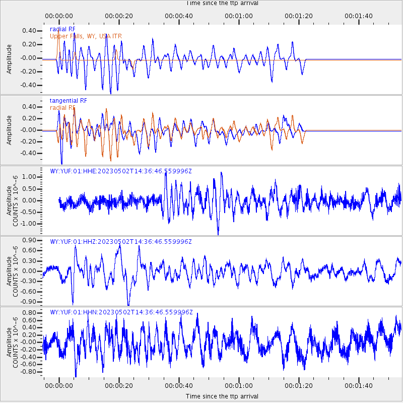
Signal To Noise
| Channel | StoN | STA | LTA |
| WY:YUF:01:HHZ:20230502T14:36:46.559996Z | 2.0147173 | 2.9747136E-7 | 1.4764919E-7 |
| WY:YUF:01:HHN:20230502T14:36:46.559996Z | 1.1167245 | 2.6684356E-7 | 2.38952E-7 |
| WY:YUF:01:HHE:20230502T14:36:46.559996Z | 1.2320855 | 2.1569065E-7 | 1.7506143E-7 |
| Arrivals |
| Ps | |
| PpPs | |
| PsPs/PpSs | |


