You are here: Home > Network List > US - United States National Seismic Network Stations List
> Station MSO Missoula, Montana, USA > Earthquake Result Viewer
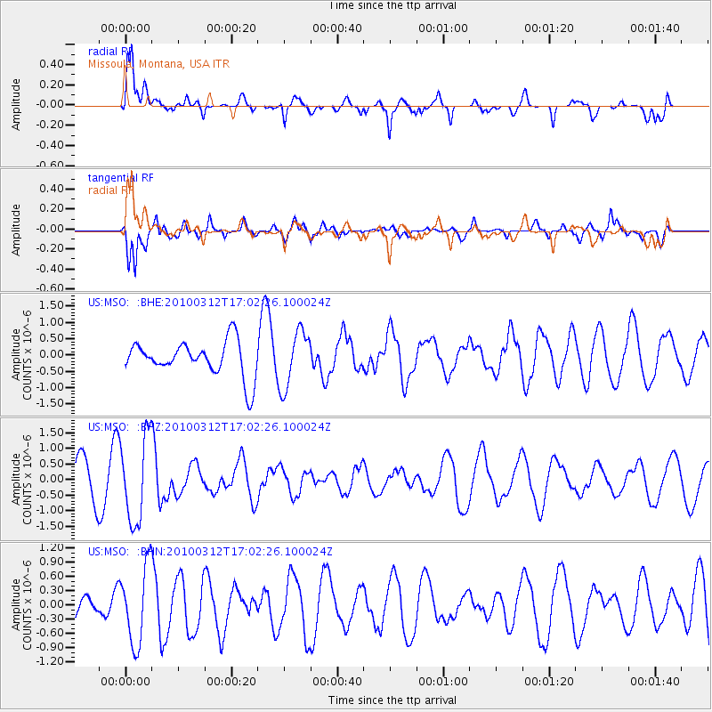
MSO Missoula, Montana, USA - Earthquake Result Viewer
*The percent match for this event was below the threshold and hence no stack was calculated.
| Earthquake location: |
Near Coast Of Central Chile |
| Earthquake latitude/longitude: |
-34.2/-71.9 |
| Earthquake time(UTC): |
2010/03/12 (071) 16:50:01 GMT |
| Earthquake Depth: |
7.0 km |
| Earthquake Magnitude: |
6.1 MB, 5.4 MS, 5.8 MW, 5.7 MW |
| Earthquake Catalog/Contributor: |
WHDF/NEIC |
|
| Network: |
US United States National Seismic Network |
| Station: |
MSO Missoula, Montana, USA |
| Lat/Lon: |
46.83 N/113.94 W |
| Elevation: |
1264 m |
|
| Distance: |
89.1 deg |
| Az: |
332.632 deg |
| Baz: |
146.31 deg |
| Ray Param: |
$rayparam |
*The percent match for this event was below the threshold and hence was not used in the summary stack. |
|
| Radial Match: |
64.33376 % |
| Radial Bump: |
400 |
| Transverse Match: |
64.27642 % |
| Transverse Bump: |
385 |
| SOD ConfigId: |
308276 |
| Insert Time: |
2010-06-22 18:22:39.847 +0000 |
| GWidth: |
2.5 |
| Max Bumps: |
400 |
| Tol: |
0.001 |
|
Signal To Noise
| Channel | StoN | STA | LTA |
| US:MSO: :BHZ:20100312T17:02:26.100024Z | 2.7915292 | 1.3528888E-6 | 4.846408E-7 |
| US:MSO: :BHN:20100312T17:02:26.100024Z | 1.4448673 | 8.126747E-7 | 5.624563E-7 |
| US:MSO: :BHE:20100312T17:02:26.100024Z | 1.6146564 | 8.7377185E-7 | 5.411503E-7 |
| Arrivals |
| Ps | |
| PpPs | |
| PsPs/PpSs | |


