You are here: Home > Network List > MM - Myanmar National Seismic Network Stations List
> Station NGU Ngaung U, Myanmar > Earthquake Result Viewer
NGU Ngaung U, Myanmar - Earthquake Result Viewer
| Earthquake location: |
New Guinea, Papua New Guinea |
| Earthquake latitude/longitude: |
-4.1/142.7 |
| Earthquake time(UTC): |
2023/05/02 (122) 20:09:59 GMT |
| Earthquake Depth: |
120 km |
| Earthquake Magnitude: |
5.5 Mww |
| Earthquake Catalog/Contributor: |
NEIC PDE/us |
|
| Network: |
MM Myanmar National Seismic Network |
| Station: |
NGU Ngaung U, Myanmar |
| Lat/Lon: |
21.21 N/94.92 E |
| Elevation: |
70 m |
|
| Distance: |
53.1 deg |
| Az: |
300.245 deg |
| Baz: |
112.558 deg |
| Ray Param: |
0.06590709 |
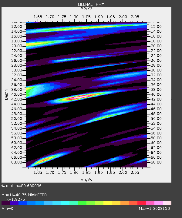
| Estimated Moho Depth: |
40.75 km |
| Estimated Crust Vp/Vs: |
1.83 |
| Assumed Crust Vp: |
6.036 km/s |
| Estimated Crust Vs: |
3.303 km/s |
| Estimated Crust Poisson's Ratio: |
0.29 |
|
| Radial Match: |
80.630936 % |
| Radial Bump: |
400 |
| Transverse Match: |
66.52888 % |
| Transverse Bump: |
395 |
| SOD ConfigId: |
30536071 |
| Insert Time: |
2023-05-16 20:22:39.409 +0000 |
| GWidth: |
2.5 |
| Max Bumps: |
400 |
| Tol: |
0.001 |
|

Signal To Noise
| Channel | StoN | STA | LTA |
| MM:NGU: :HHZ:20230502T20:18:34.280001Z | 26.617188 | 1.5893747E-6 | 5.971235E-8 |
| MM:NGU: :HHN:20230502T20:18:34.280001Z | 2.4774892 | 2.1417252E-7 | 8.644741E-8 |
| MM:NGU: :HHE:20230502T20:18:34.280001Z | 3.77355 | 3.1893018E-7 | 8.4517275E-8 |
| Arrivals |
| Ps | 5.8 SECOND |
| PpPs | 18 SECOND |
| PsPs/PpSs | 24 SECOND |


