You are here: Home > Network List > TM - Thai Seismic Monitoring Network Stations List
> Station LOEI Nam Man, Loei > Earthquake Result Viewer
LOEI Nam Man, Loei - Earthquake Result Viewer
| Earthquake location: |
New Guinea, Papua New Guinea |
| Earthquake latitude/longitude: |
-4.1/142.7 |
| Earthquake time(UTC): |
2023/05/02 (122) 20:09:59 GMT |
| Earthquake Depth: |
120 km |
| Earthquake Magnitude: |
5.5 Mww |
| Earthquake Catalog/Contributor: |
NEIC PDE/us |
|
| Network: |
TM Thai Seismic Monitoring Network |
| Station: |
LOEI Nam Man, Loei |
| Lat/Lon: |
17.51 N/101.62 E |
| Elevation: |
305 m |
|
| Distance: |
45.9 deg |
| Az: |
299.104 deg |
| Baz: |
114.029 deg |
| Ray Param: |
0.070595644 |
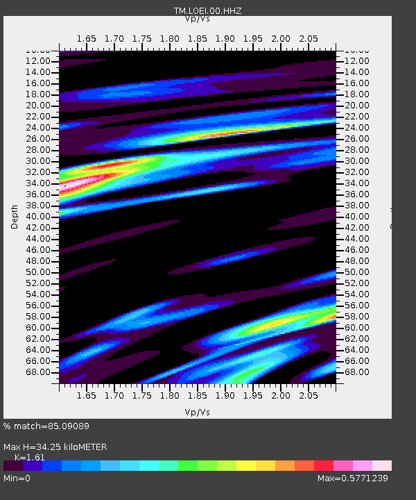
| Estimated Moho Depth: |
34.25 km |
| Estimated Crust Vp/Vs: |
1.61 |
| Assumed Crust Vp: |
6.35 km/s |
| Estimated Crust Vs: |
3.944 km/s |
| Estimated Crust Poisson's Ratio: |
0.19 |
|
| Radial Match: |
85.09089 % |
| Radial Bump: |
354 |
| Transverse Match: |
72.11602 % |
| Transverse Bump: |
400 |
| SOD ConfigId: |
30536071 |
| Insert Time: |
2023-05-16 20:24:12.484 +0000 |
| GWidth: |
2.5 |
| Max Bumps: |
400 |
| Tol: |
0.001 |
|

Signal To Noise
| Channel | StoN | STA | LTA |
| TM:LOEI:00:HHZ:20230502T20:17:39.239992Z | 15.31184 | 6.7286555E-7 | 4.3944137E-8 |
| TM:LOEI:00:HHN:20230502T20:17:39.239992Z | 2.6784503 | 1.1280656E-7 | 4.211635E-8 |
| TM:LOEI:00:HHE:20230502T20:17:39.239992Z | 8.457369 | 2.9484204E-7 | 3.4862147E-8 |
| Arrivals |
| Ps | 3.5 SECOND |
| PpPs | 13 SECOND |
| PsPs/PpSs | 17 SECOND |


