You are here: Home > Network List > MN - MEDNET Project Stations List
> Station TIP Timpagrande, Italy > Earthquake Result Viewer
TIP Timpagrande, Italy - Earthquake Result Viewer
*The percent match for this event was below the threshold and hence no stack was calculated.
| Earthquake location: |
Myanmar-India Border Region |
| Earthquake latitude/longitude: |
23.1/94.6 |
| Earthquake time(UTC): |
2010/03/12 (071) 23:19:55 GMT |
| Earthquake Depth: |
102 km |
| Earthquake Magnitude: |
5.5 MB, 5.5 MW |
| Earthquake Catalog/Contributor: |
WHDF/NEIC |
|
| Network: |
MN MEDNET Project |
| Station: |
TIP Timpagrande, Italy |
| Lat/Lon: |
39.18 N/16.76 E |
| Elevation: |
789 m |
|
| Distance: |
66.7 deg |
| Az: |
304.172 deg |
| Baz: |
78.64 deg |
| Ray Param: |
$rayparam |
*The percent match for this event was below the threshold and hence was not used in the summary stack. |
|
| Radial Match: |
64.68907 % |
| Radial Bump: |
400 |
| Transverse Match: |
82.665184 % |
| Transverse Bump: |
335 |
| SOD ConfigId: |
308276 |
| Insert Time: |
2010-06-22 18:28:34.477 +0000 |
| GWidth: |
2.5 |
| Max Bumps: |
400 |
| Tol: |
0.001 |
|
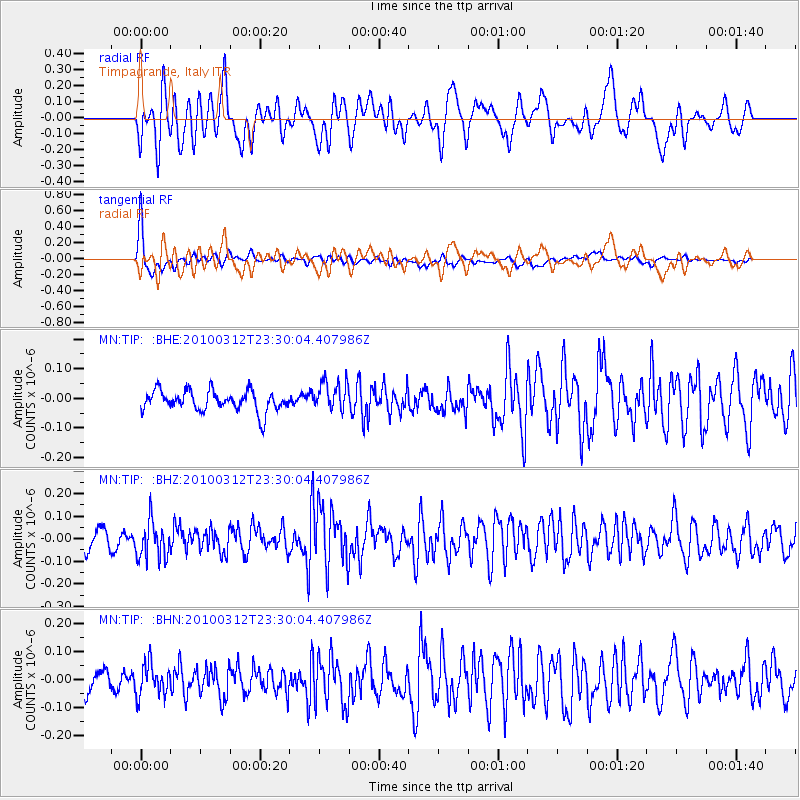
Signal To Noise
| Channel | StoN | STA | LTA |
| MN:TIP: :BHZ:20100312T23:30:04.407986Z | 2.4065306 | 8.4420606E-8 | 3.5079797E-8 |
| MN:TIP: :BHN:20100312T23:30:04.407986Z | 1.6324859 | 5.7710732E-8 | 3.5351444E-8 |
| MN:TIP: :BHE:20100312T23:30:04.407986Z | 1.4609218 | 5.0610176E-8 | 3.4642632E-8 |
| Arrivals |
| Ps | |
| PpPs | |
| PsPs/PpSs | |


