You are here: Home > Network List > TA - USArray Transportable Network (new EarthScope stations) Stations List
> Station J04D Umpqua National Forest, Toketee, OR, USA > Earthquake Result Viewer
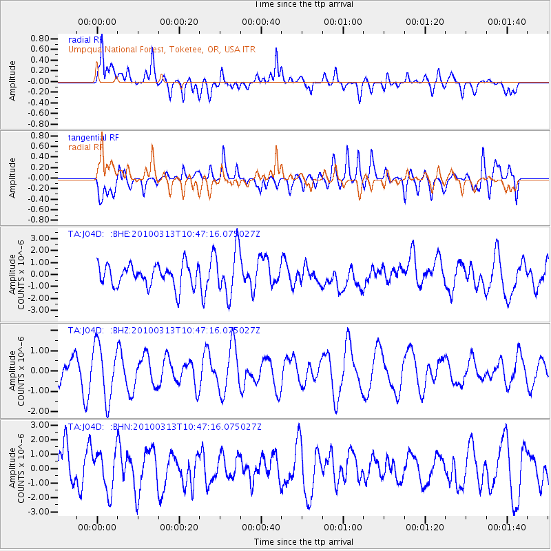
J04D Umpqua National Forest, Toketee, OR, USA - Earthquake Result Viewer
*The percent match for this event was below the threshold and hence no stack was calculated.
| Earthquake location: |
Near Coast Of Central Chile |
| Earthquake latitude/longitude: |
-37.6/-73.5 |
| Earthquake time(UTC): |
2010/03/13 (072) 10:34:43 GMT |
| Earthquake Depth: |
35 km |
| Earthquake Magnitude: |
5.5 MS, 5.2 MB, 5.8 MW, 5.7 MW |
| Earthquake Catalog/Contributor: |
WHDF/NEIC |
|
| Network: |
TA USArray Transportable Network (new EarthScope stations) |
| Station: |
J04D Umpqua National Forest, Toketee, OR, USA |
| Lat/Lon: |
43.24 N/122.11 W |
| Elevation: |
1948 m |
|
| Distance: |
91.7 deg |
| Az: |
326.716 deg |
| Baz: |
143.355 deg |
| Ray Param: |
$rayparam |
*The percent match for this event was below the threshold and hence was not used in the summary stack. |
|
| Radial Match: |
67.36083 % |
| Radial Bump: |
400 |
| Transverse Match: |
62.995895 % |
| Transverse Bump: |
400 |
| SOD ConfigId: |
308276 |
| Insert Time: |
2010-06-22 18:39:12.316 +0000 |
| GWidth: |
2.5 |
| Max Bumps: |
400 |
| Tol: |
0.001 |
|
Signal To Noise
| Channel | StoN | STA | LTA |
| TA:J04D: :BHZ:20100313T10:47:16.075027Z | 2.7025077 | 1.3540888E-6 | 5.01049E-7 |
| TA:J04D: :BHN:20100313T10:47:16.075027Z | 1.1945447 | 1.3838261E-6 | 1.1584548E-6 |
| TA:J04D: :BHE:20100313T10:47:16.075027Z | 2.1834111 | 1.9558584E-6 | 8.9578106E-7 |
| Arrivals |
| Ps | |
| PpPs | |
| PsPs/PpSs | |


