You are here: Home > Network List > AV - Alaska Volcano Observatory Stations List
> Station KICM Cape Miga, Kanaga Volcano, Alaska > Earthquake Result Viewer
KICM Cape Miga, Kanaga Volcano, Alaska - Earthquake Result Viewer
| Earthquake location: |
Near West Coast Of Honshu, Japan |
| Earthquake latitude/longitude: |
37.5/137.3 |
| Earthquake time(UTC): |
2023/05/05 (125) 05:42:04 GMT |
| Earthquake Depth: |
8.7 km |
| Earthquake Magnitude: |
6.2 mww |
| Earthquake Catalog/Contributor: |
NEIC PDE/us |
|
| Network: |
AV Alaska Volcano Observatory |
| Station: |
KICM Cape Miga, Kanaga Volcano, Alaska |
| Lat/Lon: |
51.92 N/177.20 W |
| Elevation: |
183 m |
|
| Distance: |
34.8 deg |
| Az: |
50.769 deg |
| Baz: |
263.794 deg |
| Ray Param: |
0.07758179 |
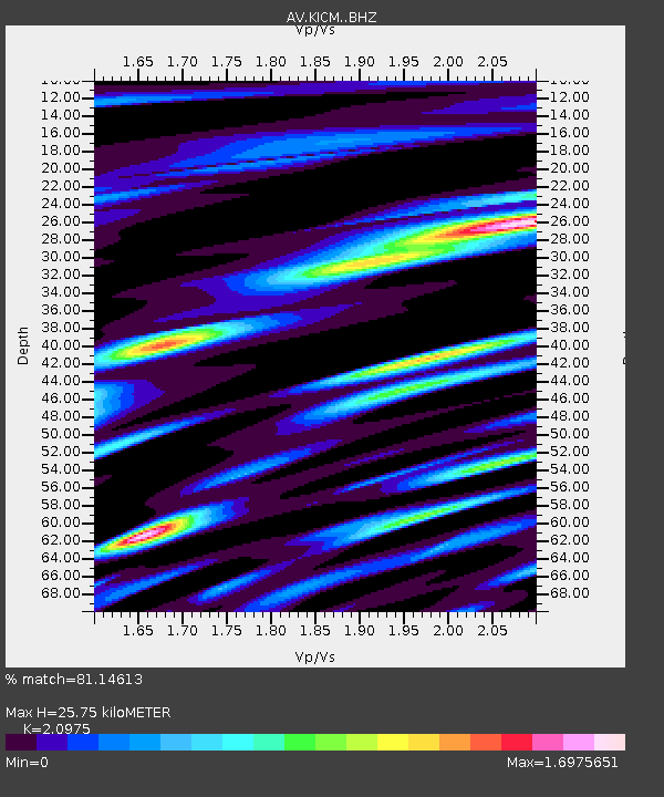
| Estimated Moho Depth: |
25.75 km |
| Estimated Crust Vp/Vs: |
2.10 |
| Assumed Crust Vp: |
5.88 km/s |
| Estimated Crust Vs: |
2.804 km/s |
| Estimated Crust Poisson's Ratio: |
0.35 |
|
| Radial Match: |
81.14613 % |
| Radial Bump: |
400 |
| Transverse Match: |
67.770035 % |
| Transverse Bump: |
400 |
| SOD ConfigId: |
30536071 |
| Insert Time: |
2023-05-19 05:52:26.093 +0000 |
| GWidth: |
2.5 |
| Max Bumps: |
400 |
| Tol: |
0.001 |
|

Signal To Noise
| Channel | StoN | STA | LTA |
| AV:KICM: :BHZ:20230505T05:48:24.220009Z | 9.254593 | 4.6799923E-6 | 5.05694E-7 |
| AV:KICM: :BHN:20230505T05:48:24.220009Z | 1.033223 | 1.0497776E-6 | 1.0160222E-6 |
| AV:KICM: :BHE:20230505T05:48:24.220009Z | 3.8239923 | 3.2393043E-6 | 8.471001E-7 |
| Arrivals |
| Ps | 5.1 SECOND |
| PpPs | 13 SECOND |
| PsPs/PpSs | 18 SECOND |


