You are here: Home > Network List > AV - Alaska Volcano Observatory Stations List
> Station MNAT Nateekin Bay, Makushin Volcano, Alaska > Earthquake Result Viewer
MNAT Nateekin Bay, Makushin Volcano, Alaska - Earthquake Result Viewer
| Earthquake location: |
Near West Coast Of Honshu, Japan |
| Earthquake latitude/longitude: |
37.5/137.3 |
| Earthquake time(UTC): |
2023/05/05 (125) 05:42:04 GMT |
| Earthquake Depth: |
8.7 km |
| Earthquake Magnitude: |
6.2 mww |
| Earthquake Catalog/Contributor: |
NEIC PDE/us |
|
| Network: |
AV Alaska Volcano Observatory |
| Station: |
MNAT Nateekin Bay, Makushin Volcano, Alaska |
| Lat/Lon: |
53.88 N/166.69 W |
| Elevation: |
390 m |
|
| Distance: |
41.2 deg |
| Az: |
48.14 deg |
| Baz: |
270.092 deg |
| Ray Param: |
0.0739284 |
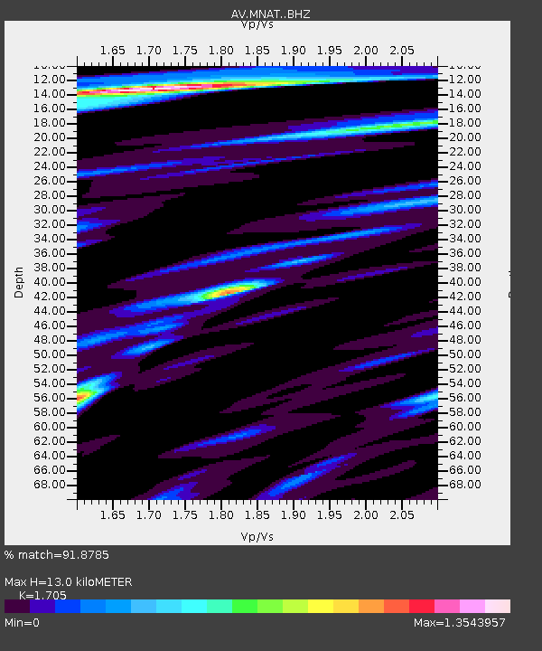
| Estimated Moho Depth: |
13.0 km |
| Estimated Crust Vp/Vs: |
1.71 |
| Assumed Crust Vp: |
3.943 km/s |
| Estimated Crust Vs: |
2.313 km/s |
| Estimated Crust Poisson's Ratio: |
0.24 |
|
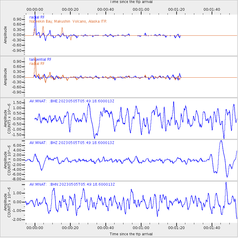
| Radial Match: |
91.8785 % |
| Radial Bump: |
267 |
| Transverse Match: |
53.758114 % |
| Transverse Bump: |
400 |
| SOD ConfigId: |
30536071 |
| Insert Time: |
2023-05-19 05:52:49.616 +0000 |
| GWidth: |
2.5 |
| Max Bumps: |
400 |
| Tol: |
0.001 |
|
Signal To Noise
| Channel | StoN | STA | LTA |
| AV:MNAT: :BHZ:20230505T05:49:18.600013Z | 7.8468213 | 2.1801732E-6 | 2.7784156E-7 |
| AV:MNAT: :BHN:20230505T05:49:18.600013Z | 0.65447634 | 2.3700103E-7 | 3.6212313E-7 |
| AV:MNAT: :BHE:20230505T05:49:18.600013Z | 3.455351 | 1.0811013E-6 | 3.1287743E-7 |
| Arrivals |
| Ps | 2.4 SECOND |
| PpPs | 8.7 SECOND |
| PsPs/PpSs | 11 SECOND |


