You are here: Home > Network List > AV - Alaska Volcano Observatory Stations List
> Station SPCN Ckakachatna North Broadband, Mount Spurr, Alaska > Earthquake Result Viewer
SPCN Ckakachatna North Broadband, Mount Spurr, Alaska - Earthquake Result Viewer
| Earthquake location: |
Near West Coast Of Honshu, Japan |
| Earthquake latitude/longitude: |
37.5/137.3 |
| Earthquake time(UTC): |
2023/05/05 (125) 05:42:04 GMT |
| Earthquake Depth: |
8.7 km |
| Earthquake Magnitude: |
6.2 mww |
| Earthquake Catalog/Contributor: |
NEIC PDE/us |
|
| Network: |
AV Alaska Volcano Observatory |
| Station: |
SPCN Ckakachatna North Broadband, Mount Spurr, Alaska |
| Lat/Lon: |
61.22 N/152.19 W |
| Elevation: |
735 m |
|
| Distance: |
48.8 deg |
| Az: |
37.35 deg |
| Baz: |
274.69 deg |
| Ray Param: |
0.06916293 |
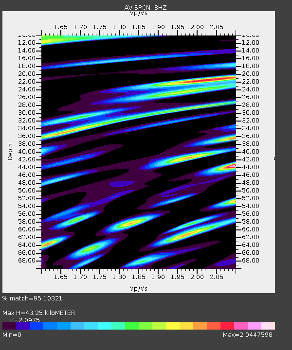
| Estimated Moho Depth: |
43.25 km |
| Estimated Crust Vp/Vs: |
2.10 |
| Assumed Crust Vp: |
6.566 km/s |
| Estimated Crust Vs: |
3.13 km/s |
| Estimated Crust Poisson's Ratio: |
0.35 |
|
| Radial Match: |
95.10321 % |
| Radial Bump: |
400 |
| Transverse Match: |
92.04359 % |
| Transverse Bump: |
400 |
| SOD ConfigId: |
30536071 |
| Insert Time: |
2023-05-19 05:53:49.740 +0000 |
| GWidth: |
2.5 |
| Max Bumps: |
400 |
| Tol: |
0.001 |
|
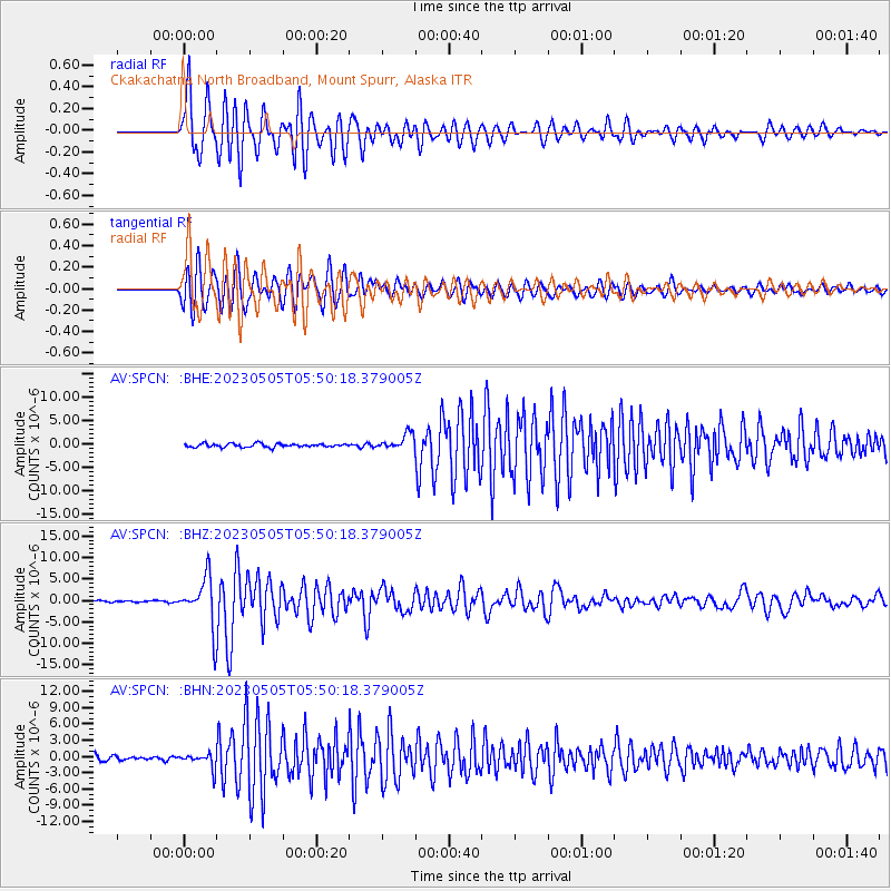
Signal To Noise
| Channel | StoN | STA | LTA |
| AV:SPCN: :BHZ:20230505T05:50:18.379005Z | 37.81582 | 6.042052E-6 | 1.5977578E-7 |
| AV:SPCN: :BHN:20230505T05:50:18.379005Z | 3.1262202 | 1.4204763E-6 | 4.54375E-7 |
| AV:SPCN: :BHE:20230505T05:50:18.379005Z | 4.6953535 | 1.7329465E-6 | 3.690769E-7 |
| Arrivals |
| Ps | 7.6 SECOND |
| PpPs | 19 SECOND |
| PsPs/PpSs | 27 SECOND |


