You are here: Home > Network List > C0 - Colorado Geological Survey Seismic Network Stations List
> Station T25A Trinidad, CO > Earthquake Result Viewer
T25A Trinidad, CO - Earthquake Result Viewer
| Earthquake location: |
Near West Coast Of Honshu, Japan |
| Earthquake latitude/longitude: |
37.5/137.3 |
| Earthquake time(UTC): |
2023/05/05 (125) 05:42:04 GMT |
| Earthquake Depth: |
8.7 km |
| Earthquake Magnitude: |
6.2 mww |
| Earthquake Catalog/Contributor: |
NEIC PDE/us |
|
| Network: |
C0 Colorado Geological Survey Seismic Network |
| Station: |
T25A Trinidad, CO |
| Lat/Lon: |
37.08 N/104.25 W |
| Elevation: |
1800 m |
|
| Distance: |
86.5 deg |
| Az: |
44.787 deg |
| Baz: |
315.554 deg |
| Ray Param: |
0.04402779 |
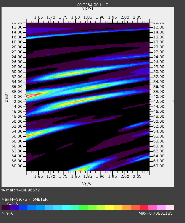
| Estimated Moho Depth: |
39.75 km |
| Estimated Crust Vp/Vs: |
1.60 |
| Assumed Crust Vp: |
6.316 km/s |
| Estimated Crust Vs: |
3.947 km/s |
| Estimated Crust Poisson's Ratio: |
0.18 |
|
| Radial Match: |
84.96672 % |
| Radial Bump: |
304 |
| Transverse Match: |
81.38363 % |
| Transverse Bump: |
389 |
| SOD ConfigId: |
30536071 |
| Insert Time: |
2023-05-19 05:56:07.923 +0000 |
| GWidth: |
2.5 |
| Max Bumps: |
400 |
| Tol: |
0.001 |
|

Signal To Noise
| Channel | StoN | STA | LTA |
| C0:T25A:00:HHZ:20230505T05:54:15.16999Z | 21.464241 | 2.1988542E-6 | 1.0244268E-7 |
| C0:T25A:00:HHN:20230505T05:54:15.16999Z | 5.5515847 | 6.9047604E-7 | 1.2437458E-7 |
| C0:T25A:00:HHE:20230505T05:54:15.16999Z | 1.8497226 | 3.4073804E-7 | 1.8421035E-7 |
| Arrivals |
| Ps | 3.9 SECOND |
| PpPs | 16 SECOND |
| PsPs/PpSs | 20 SECOND |


