You are here: Home > Network List > GM - US Geological Survey Networks Stations List
> Station NMP41 New Mexico Permian - Site# W4S1 > Earthquake Result Viewer
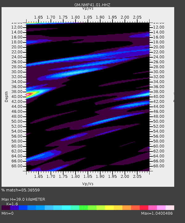
NMP41 New Mexico Permian - Site# W4S1 - Earthquake Result Viewer
| Earthquake location: |
Near West Coast Of Honshu, Japan |
| Earthquake latitude/longitude: |
37.5/137.3 |
| Earthquake time(UTC): |
2023/05/05 (125) 05:42:04 GMT |
| Earthquake Depth: |
8.7 km |
| Earthquake Magnitude: |
6.2 mww |
| Earthquake Catalog/Contributor: |
NEIC PDE/us |
|
| Network: |
GM US Geological Survey Networks |
| Station: |
NMP41 New Mexico Permian - Site# W4S1 |
| Lat/Lon: |
32.01 N/103.60 W |
| Elevation: |
960 m |
|
| Distance: |
90.5 deg |
| Az: |
47.936 deg |
| Baz: |
316.005 deg |
| Ray Param: |
0.041701123 |
| Estimated Moho Depth: |
39.0 km |
| Estimated Crust Vp/Vs: |
1.60 |
| Assumed Crust Vp: |
6.129 km/s |
| Estimated Crust Vs: |
3.831 km/s |
| Estimated Crust Poisson's Ratio: |
0.18 |
|
| Radial Match: |
85.36559 % |
| Radial Bump: |
400 |
| Transverse Match: |
74.14034 % |
| Transverse Bump: |
400 |
| SOD ConfigId: |
30536071 |
| Insert Time: |
2023-05-19 06:06:09.577 +0000 |
| GWidth: |
2.5 |
| Max Bumps: |
400 |
| Tol: |
0.001 |
|

Signal To Noise
| Channel | StoN | STA | LTA |
| GM:NMP41:01:HHZ:20230505T05:54:34.765022Z | 4.024898 | 1.6592157E-6 | 4.12238E-7 |
| GM:NMP41:01:HHN:20230505T05:54:34.765022Z | 1.5967304 | 4.1141115E-7 | 2.576585E-7 |
| GM:NMP41:01:HHE:20230505T05:54:34.765022Z | 1.3291861 | 2.2022527E-7 | 1.6568431E-7 |
| Arrivals |
| Ps | 3.9 SECOND |
| PpPs | 16 SECOND |
| PsPs/PpSs | 20 SECOND |


