You are here: Home > Network List > KN - Kyrgyz Seismic Telemetry Network Stations List
> Station TKM2 KN.TKM2 > Earthquake Result Viewer
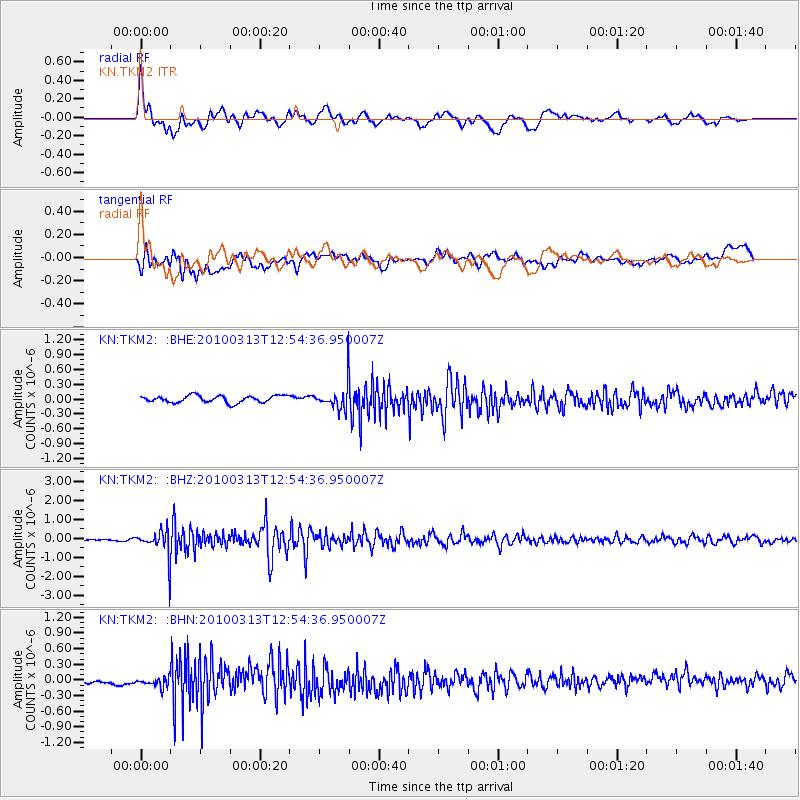
TKM2 KN.TKM2 - Earthquake Result Viewer
*The percent match for this event was below the threshold and hence no stack was calculated.
| Earthquake location: |
Near East Coast Of Honshu, Japan |
| Earthquake latitude/longitude: |
37.6/141.3 |
| Earthquake time(UTC): |
2010/03/13 (072) 12:46:26 GMT |
| Earthquake Depth: |
77 km |
| Earthquake Magnitude: |
5.7 MB, 5.6 MW, 5.5 MW |
| Earthquake Catalog/Contributor: |
WHDF/NEIC |
|
| Network: |
KN Kyrgyz Seismic Telemetry Network |
| Station: |
TKM2 KN.TKM2 |
| Lat/Lon: |
42.92 N/75.60 E |
| Elevation: |
2020 m |
|
| Distance: |
49.3 deg |
| Az: |
297.958 deg |
| Baz: |
72.774 deg |
| Ray Param: |
$rayparam |
*The percent match for this event was below the threshold and hence was not used in the summary stack. |
|
| Radial Match: |
77.49484 % |
| Radial Bump: |
400 |
| Transverse Match: |
59.214912 % |
| Transverse Bump: |
400 |
| SOD ConfigId: |
308276 |
| Insert Time: |
2010-06-22 18:51:06.406 +0000 |
| GWidth: |
2.5 |
| Max Bumps: |
400 |
| Tol: |
0.001 |
|
Signal To Noise
| Channel | StoN | STA | LTA |
| KN:TKM2: :BHZ:20100313T12:54:36.950007Z | 21.767744 | 6.9782504E-7 | 3.2057756E-8 |
| KN:TKM2: :BHN:20100313T12:54:36.950007Z | 1.8314143 | 1.216058E-7 | 6.6399934E-8 |
| KN:TKM2: :BHE:20100313T12:54:36.950007Z | 3.8406053 | 2.653097E-7 | 6.908018E-8 |
| Arrivals |
| Ps | |
| PpPs | |
| PsPs/PpSs | |


