You are here: Home > Network List > NE - New England Seismic Network Stations List
> Station EMMW Machias, ME, USA > Earthquake Result Viewer
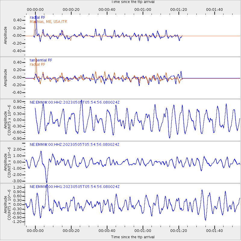
EMMW Machias, ME, USA - Earthquake Result Viewer
*The percent match for this event was below the threshold and hence no stack was calculated.
| Earthquake location: |
Near West Coast Of Honshu, Japan |
| Earthquake latitude/longitude: |
37.5/137.3 |
| Earthquake time(UTC): |
2023/05/05 (125) 05:42:04 GMT |
| Earthquake Depth: |
8.7 km |
| Earthquake Magnitude: |
6.2 mww |
| Earthquake Catalog/Contributor: |
NEIC PDE/us |
|
| Network: |
NE New England Seismic Network |
| Station: |
EMMW Machias, ME, USA |
| Lat/Lon: |
44.71 N/67.46 W |
| Elevation: |
35 m |
|
| Distance: |
95.1 deg |
| Az: |
17.45 deg |
| Baz: |
340.471 deg |
| Ray Param: |
$rayparam |
*The percent match for this event was below the threshold and hence was not used in the summary stack. |
|
| Radial Match: |
65.9346 % |
| Radial Bump: |
327 |
| Transverse Match: |
54.838234 % |
| Transverse Bump: |
344 |
| SOD ConfigId: |
30536071 |
| Insert Time: |
2023-05-19 06:13:52.352 +0000 |
| GWidth: |
2.5 |
| Max Bumps: |
400 |
| Tol: |
0.001 |
|
Signal To Noise
| Channel | StoN | STA | LTA |
| NE:EMMW:00:HHZ:20230505T05:54:56.080024Z | 2.5848413 | 7.6326177E-7 | 2.9528383E-7 |
| NE:EMMW:00:HH1:20230505T05:54:56.080024Z | 1.8683381 | 5.4135387E-7 | 2.8975157E-7 |
| NE:EMMW:00:HH2:20230505T05:54:56.080024Z | 0.9670576 | 3.387396E-7 | 3.5027864E-7 |
| Arrivals |
| Ps | |
| PpPs | |
| PsPs/PpSs | |


