You are here: Home > Network List > GS - US Geological Survey Networks Stations List
> Station OK048 Pawnee, OK, Station 48 > Earthquake Result Viewer
OK048 Pawnee, OK, Station 48 - Earthquake Result Viewer
| Earthquake location: |
Ionian Sea |
| Earthquake latitude/longitude: |
37.5/20.6 |
| Earthquake time(UTC): |
2018/10/25 (298) 22:54:52 GMT |
| Earthquake Depth: |
14 km |
| Earthquake Magnitude: |
6.8 Mww |
| Earthquake Catalog/Contributor: |
NEIC PDE/us |
|
| Network: |
GS US Geological Survey Networks |
| Station: |
OK048 Pawnee, OK, Station 48 |
| Lat/Lon: |
36.42 N/96.94 W |
| Elevation: |
297 m |
|
| Distance: |
86.4 deg |
| Az: |
314.207 deg |
| Baz: |
44.962 deg |
| Ray Param: |
0.04404731 |
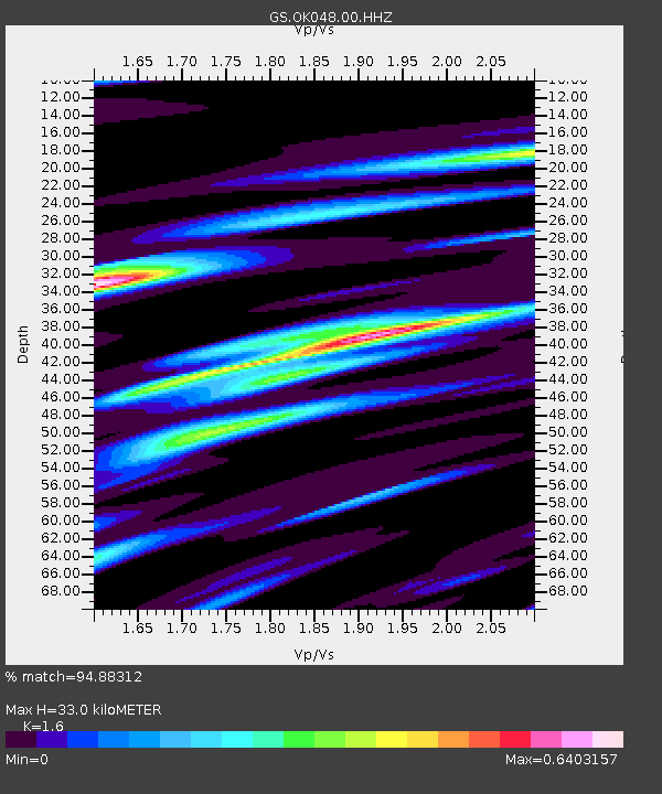
| Estimated Moho Depth: |
33.0 km |
| Estimated Crust Vp/Vs: |
1.60 |
| Assumed Crust Vp: |
6.483 km/s |
| Estimated Crust Vs: |
4.052 km/s |
| Estimated Crust Poisson's Ratio: |
0.18 |
|
| Radial Match: |
94.88312 % |
| Radial Bump: |
314 |
| Transverse Match: |
63.532475 % |
| Transverse Bump: |
400 |
| SOD ConfigId: |
3103472 |
| Insert Time: |
2018-11-09 16:49:38.561 +0000 |
| GWidth: |
2.5 |
| Max Bumps: |
400 |
| Tol: |
0.001 |
|

Signal To Noise
| Channel | StoN | STA | LTA |
| GS:OK048:00:HHZ:20181025T23:07:03.014988Z | 4.206054 | 9.3052387E-7 | 2.212344E-7 |
| GS:OK048:00:HH1:20181025T23:07:03.014988Z | 2.6102703 | 4.4627583E-7 | 1.7096922E-7 |
| GS:OK048:00:HH2:20181025T23:07:03.014988Z | 1.6969706 | 6.0925817E-7 | 3.5902696E-7 |
| Arrivals |
| Ps | 3.1 SECOND |
| PpPs | 13 SECOND |
| PsPs/PpSs | 16 SECOND |


