You are here: Home > Network List > O2 - Oklahoma Consolidated Temporary Seismic Networks Stations List
> Station FW03 Mooreland, Oklahoma, USA > Earthquake Result Viewer
FW03 Mooreland, Oklahoma, USA - Earthquake Result Viewer
| Earthquake location: |
Near West Coast Of Honshu, Japan |
| Earthquake latitude/longitude: |
37.5/137.3 |
| Earthquake time(UTC): |
2023/05/05 (125) 05:42:04 GMT |
| Earthquake Depth: |
8.7 km |
| Earthquake Magnitude: |
6.2 mww |
| Earthquake Catalog/Contributor: |
NEIC PDE/us |
|
| Network: |
O2 Oklahoma Consolidated Temporary Seismic Networks |
| Station: |
FW03 Mooreland, Oklahoma, USA |
| Lat/Lon: |
36.53 N/99.17 W |
| Elevation: |
628 m |
|
| Distance: |
89.7 deg |
| Az: |
42.185 deg |
| Baz: |
318.494 deg |
| Ray Param: |
0.041733112 |
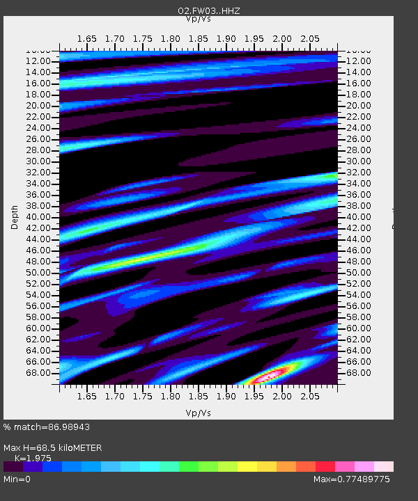
| Estimated Moho Depth: |
68.5 km |
| Estimated Crust Vp/Vs: |
1.98 |
| Assumed Crust Vp: |
6.426 km/s |
| Estimated Crust Vs: |
3.254 km/s |
| Estimated Crust Poisson's Ratio: |
0.33 |
|
| Radial Match: |
86.98943 % |
| Radial Bump: |
245 |
| Transverse Match: |
84.72929 % |
| Transverse Bump: |
400 |
| SOD ConfigId: |
30536071 |
| Insert Time: |
2023-05-19 06:16:22.613 +0000 |
| GWidth: |
2.5 |
| Max Bumps: |
400 |
| Tol: |
0.001 |
|

Signal To Noise
| Channel | StoN | STA | LTA |
| O2:FW03: :HHZ:20230505T05:54:30.960029Z | 11.028617 | 1.8872015E-6 | 1.711186E-7 |
| O2:FW03: :HHN:20230505T05:54:30.960029Z | 1.7583877 | 4.880207E-7 | 2.7753876E-7 |
| O2:FW03: :HHE:20230505T05:54:30.960029Z | 2.4204736 | 4.6846162E-7 | 1.935413E-7 |
| Arrivals |
| Ps | 11 SECOND |
| PpPs | 31 SECOND |
| PsPs/PpSs | 42 SECOND |


