You are here: Home > Network List > O2 - Oklahoma Consolidated Temporary Seismic Networks Stations List
> Station MRSH Marshall, Oklahoma, USA > Earthquake Result Viewer
MRSH Marshall, Oklahoma, USA - Earthquake Result Viewer
| Earthquake location: |
Near West Coast Of Honshu, Japan |
| Earthquake latitude/longitude: |
37.5/137.3 |
| Earthquake time(UTC): |
2023/05/05 (125) 05:42:04 GMT |
| Earthquake Depth: |
8.7 km |
| Earthquake Magnitude: |
6.2 mww |
| Earthquake Catalog/Contributor: |
NEIC PDE/us |
|
| Network: |
O2 Oklahoma Consolidated Temporary Seismic Networks |
| Station: |
MRSH Marshall, Oklahoma, USA |
| Lat/Lon: |
36.13 N/97.70 W |
| Elevation: |
309 m |
|
| Distance: |
90.7 deg |
| Az: |
41.544 deg |
| Baz: |
319.368 deg |
| Ray Param: |
0.041681334 |
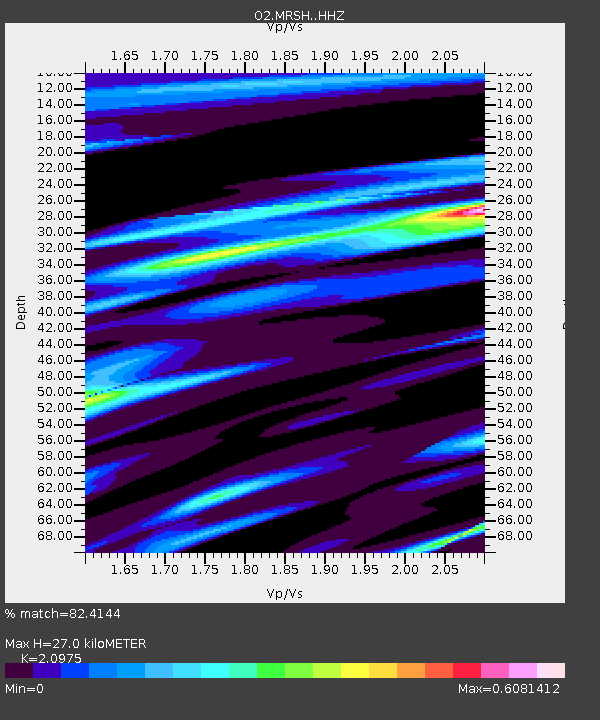
| Estimated Moho Depth: |
27.0 km |
| Estimated Crust Vp/Vs: |
2.10 |
| Assumed Crust Vp: |
6.483 km/s |
| Estimated Crust Vs: |
3.091 km/s |
| Estimated Crust Poisson's Ratio: |
0.35 |
|
| Radial Match: |
82.4144 % |
| Radial Bump: |
252 |
| Transverse Match: |
78.91848 % |
| Transverse Bump: |
395 |
| SOD ConfigId: |
30536071 |
| Insert Time: |
2023-05-19 06:16:35.056 +0000 |
| GWidth: |
2.5 |
| Max Bumps: |
400 |
| Tol: |
0.001 |
|

Signal To Noise
| Channel | StoN | STA | LTA |
| O2:MRSH: :HHZ:20230505T05:54:35.955024Z | 8.838543 | 1.7903653E-6 | 2.0256338E-7 |
| O2:MRSH: :HHN:20230505T05:54:35.955024Z | 1.8395376 | 5.6579063E-7 | 3.0757218E-7 |
| O2:MRSH: :HHE:20230505T05:54:35.955024Z | 3.343754 | 5.4056807E-7 | 1.6166501E-7 |
| Arrivals |
| Ps | 4.7 SECOND |
| PpPs | 13 SECOND |
| PsPs/PpSs | 17 SECOND |


