You are here: Home > Network List > PQ - Public Safety Geoscience Program Canadian Research Network (PSGP) Stations List
> Station ULUN Ulukhaktok, Victoria Island, NWT, Canada > Earthquake Result Viewer
ULUN Ulukhaktok, Victoria Island, NWT, Canada - Earthquake Result Viewer
| Earthquake location: |
Near West Coast Of Honshu, Japan |
| Earthquake latitude/longitude: |
37.5/137.3 |
| Earthquake time(UTC): |
2023/05/05 (125) 05:42:04 GMT |
| Earthquake Depth: |
8.7 km |
| Earthquake Magnitude: |
6.2 mww |
| Earthquake Catalog/Contributor: |
NEIC PDE/us |
|
| Network: |
PQ Public Safety Geoscience Program Canadian Research Network (PSGP) |
| Station: |
ULUN Ulukhaktok, Victoria Island, NWT, Canada |
| Lat/Lon: |
70.74 N/117.76 W |
| Elevation: |
5.0 m |
|
| Distance: |
59.7 deg |
| Az: |
21.801 deg |
| Baz: |
297.192 deg |
| Ray Param: |
0.06201321 |
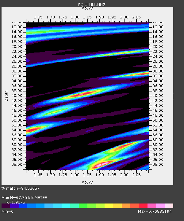
| Estimated Moho Depth: |
67.75 km |
| Estimated Crust Vp/Vs: |
1.91 |
| Assumed Crust Vp: |
6.367 km/s |
| Estimated Crust Vs: |
3.338 km/s |
| Estimated Crust Poisson's Ratio: |
0.31 |
|
| Radial Match: |
94.53057 % |
| Radial Bump: |
400 |
| Transverse Match: |
40.246735 % |
| Transverse Bump: |
400 |
| SOD ConfigId: |
30536071 |
| Insert Time: |
2023-05-19 06:19:48.875 +0000 |
| GWidth: |
2.5 |
| Max Bumps: |
400 |
| Tol: |
0.001 |
|

Signal To Noise
| Channel | StoN | STA | LTA |
| PQ:ULUN: :HHZ:20230505T05:51:38.070015Z | 27.597343 | 2.73108E-6 | 9.89617E-8 |
| PQ:ULUN: :HHN:20230505T05:51:38.070015Z | 1.8469813 | 5.487145E-7 | 2.9708724E-7 |
| PQ:ULUN: :HHE:20230505T05:51:38.070015Z | 10.118696 | 1.1540869E-6 | 1.14054906E-7 |
| Arrivals |
| Ps | 10 SECOND |
| PpPs | 30 SECOND |
| PsPs/PpSs | 40 SECOND |


