You are here: Home > Network List > II - Global Seismograph Network (GSN - IRIS/IDA) Stations List
> Station ABPO Ambohimpanompo, Madagascar > Earthquake Result Viewer
ABPO Ambohimpanompo, Madagascar - Earthquake Result Viewer
| Earthquake location: |
Ionian Sea |
| Earthquake latitude/longitude: |
37.5/20.6 |
| Earthquake time(UTC): |
2018/10/25 (298) 22:54:52 GMT |
| Earthquake Depth: |
14 km |
| Earthquake Magnitude: |
6.8 Mww |
| Earthquake Catalog/Contributor: |
NEIC PDE/us |
|
| Network: |
II Global Seismograph Network (GSN - IRIS/IDA) |
| Station: |
ABPO Ambohimpanompo, Madagascar |
| Lat/Lon: |
19.02 S/47.23 E |
| Elevation: |
1528 m |
|
| Distance: |
61.6 deg |
| Az: |
151.135 deg |
| Baz: |
336.063 deg |
| Ray Param: |
0.060771767 |
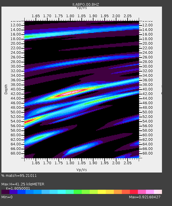
| Estimated Moho Depth: |
41.25 km |
| Estimated Crust Vp/Vs: |
1.81 |
| Assumed Crust Vp: |
6.642 km/s |
| Estimated Crust Vs: |
3.68 km/s |
| Estimated Crust Poisson's Ratio: |
0.28 |
|
| Radial Match: |
95.21011 % |
| Radial Bump: |
376 |
| Transverse Match: |
77.064705 % |
| Transverse Bump: |
400 |
| SOD ConfigId: |
3103472 |
| Insert Time: |
2018-11-09 16:49:58.719 +0000 |
| GWidth: |
2.5 |
| Max Bumps: |
400 |
| Tol: |
0.001 |
|

Signal To Noise
| Channel | StoN | STA | LTA |
| II:ABPO:00:BHZ:20181025T23:04:38.269016Z | 9.761117 | 2.005296E-6 | 2.0543713E-7 |
| II:ABPO:00:BH1:20181025T23:04:38.269016Z | 7.256497 | 8.2073535E-7 | 1.13103525E-7 |
| II:ABPO:00:BH2:20181025T23:04:38.269016Z | 3.112428 | 2.8380873E-7 | 9.118564E-8 |
| Arrivals |
| Ps | 5.2 SECOND |
| PpPs | 17 SECOND |
| PsPs/PpSs | 22 SECOND |


