You are here: Home > Network List > TA - USArray Transportable Network (new EarthScope stations) Stations List
> Station D22A Cohagen, MT, USA > Earthquake Result Viewer
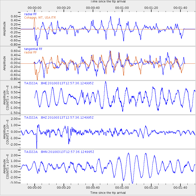
D22A Cohagen, MT, USA - Earthquake Result Viewer
*The percent match for this event was below the threshold and hence no stack was calculated.
| Earthquake location: |
Near East Coast Of Honshu, Japan |
| Earthquake latitude/longitude: |
37.6/141.3 |
| Earthquake time(UTC): |
2010/03/13 (072) 12:46:26 GMT |
| Earthquake Depth: |
77 km |
| Earthquake Magnitude: |
5.7 MB, 5.6 MW, 5.5 MW |
| Earthquake Catalog/Contributor: |
WHDF/NEIC |
|
| Network: |
TA USArray Transportable Network (new EarthScope stations) |
| Station: |
D22A Cohagen, MT, USA |
| Lat/Lon: |
47.15 N/106.18 W |
| Elevation: |
791 m |
|
| Distance: |
76.3 deg |
| Az: |
40.456 deg |
| Baz: |
310.962 deg |
| Ray Param: |
$rayparam |
*The percent match for this event was below the threshold and hence was not used in the summary stack. |
|
| Radial Match: |
62.542355 % |
| Radial Bump: |
400 |
| Transverse Match: |
79.134285 % |
| Transverse Bump: |
400 |
| SOD ConfigId: |
308276 |
| Insert Time: |
2010-06-22 18:58:54.946 +0000 |
| GWidth: |
2.5 |
| Max Bumps: |
400 |
| Tol: |
0.001 |
|
Signal To Noise
| Channel | StoN | STA | LTA |
| TA:D22A: :BHZ:20100313T12:57:36.124995Z | 3.3617034 | 7.739752E-7 | 2.3023306E-7 |
| TA:D22A: :BHN:20100313T12:57:36.124995Z | 1.519415 | 7.292102E-7 | 4.799283E-7 |
| TA:D22A: :BHE:20100313T12:57:36.124995Z | 0.7829852 | 4.3051728E-7 | 5.498408E-7 |
| Arrivals |
| Ps | |
| PpPs | |
| PsPs/PpSs | |


