You are here: Home > Network List > RV - Regional Alberta Seismic Observatory for Earthquake Studies Network Stations List
> Station LGPLA Lodgepole, AB > Earthquake Result Viewer
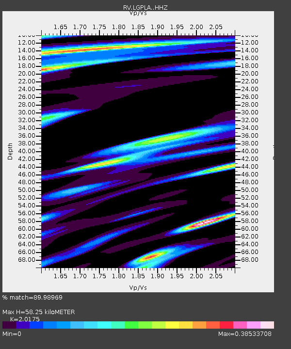
LGPLA Lodgepole, AB - Earthquake Result Viewer
| Earthquake location: |
Near West Coast Of Honshu, Japan |
| Earthquake latitude/longitude: |
37.5/137.3 |
| Earthquake time(UTC): |
2023/05/05 (125) 05:42:04 GMT |
| Earthquake Depth: |
8.7 km |
| Earthquake Magnitude: |
6.2 mww |
| Earthquake Catalog/Contributor: |
NEIC PDE/us |
|
| Network: |
RV Regional Alberta Seismic Observatory for Earthquake Studies Network |
| Station: |
LGPLA Lodgepole, AB |
| Lat/Lon: |
53.11 N/115.36 W |
| Elevation: |
886 m |
|
| Distance: |
70.0 deg |
| Az: |
37.746 deg |
| Baz: |
306.172 deg |
| Ray Param: |
0.055261903 |
| Estimated Moho Depth: |
58.25 km |
| Estimated Crust Vp/Vs: |
2.02 |
| Assumed Crust Vp: |
6.426 km/s |
| Estimated Crust Vs: |
3.185 km/s |
| Estimated Crust Poisson's Ratio: |
0.34 |
|
| Radial Match: |
89.98969 % |
| Radial Bump: |
374 |
| Transverse Match: |
63.3764 % |
| Transverse Bump: |
400 |
| SOD ConfigId: |
30536071 |
| Insert Time: |
2023-05-19 06:20:57.535 +0000 |
| GWidth: |
2.5 |
| Max Bumps: |
400 |
| Tol: |
0.001 |
|

Signal To Noise
| Channel | StoN | STA | LTA |
| RV:LGPLA: :HHZ:20230505T05:52:45.210029Z | 17.119642 | 2.8969346E-6 | 1.69217E-7 |
| RV:LGPLA: :HHN:20230505T05:52:45.210029Z | 2.4572496 | 5.612147E-7 | 2.2839139E-7 |
| RV:LGPLA: :HHE:20230505T05:52:45.210029Z | 3.223652 | 6.9844765E-7 | 2.1666348E-7 |
| Arrivals |
| Ps | 9.5 SECOND |
| PpPs | 26 SECOND |
| PsPs/PpSs | 36 SECOND |


