You are here: Home > Network List > TA - USArray Transportable Network (new EarthScope stations) Stations List
> Station R23A Moffat, CO, USA > Earthquake Result Viewer
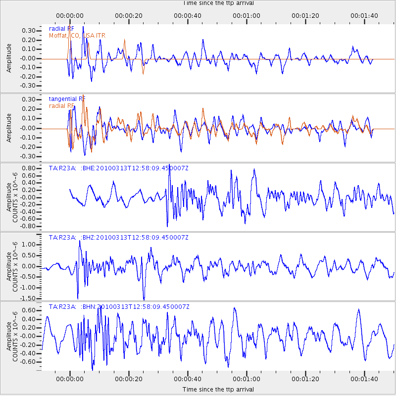
R23A Moffat, CO, USA - Earthquake Result Viewer
*The percent match for this event was below the threshold and hence no stack was calculated.
| Earthquake location: |
Near East Coast Of Honshu, Japan |
| Earthquake latitude/longitude: |
37.6/141.3 |
| Earthquake time(UTC): |
2010/03/13 (072) 12:46:26 GMT |
| Earthquake Depth: |
77 km |
| Earthquake Magnitude: |
5.7 MB, 5.6 MW, 5.5 MW |
| Earthquake Catalog/Contributor: |
WHDF/NEIC |
|
| Network: |
TA USArray Transportable Network (new EarthScope stations) |
| Station: |
R23A Moffat, CO, USA |
| Lat/Lon: |
38.19 N/105.83 W |
| Elevation: |
2547 m |
|
| Distance: |
82.5 deg |
| Az: |
47.078 deg |
| Baz: |
312.422 deg |
| Ray Param: |
$rayparam |
*The percent match for this event was below the threshold and hence was not used in the summary stack. |
|
| Radial Match: |
65.38996 % |
| Radial Bump: |
400 |
| Transverse Match: |
62.493423 % |
| Transverse Bump: |
400 |
| SOD ConfigId: |
308276 |
| Insert Time: |
2010-06-22 19:00:43.772 +0000 |
| GWidth: |
2.5 |
| Max Bumps: |
400 |
| Tol: |
0.001 |
|
Signal To Noise
| Channel | StoN | STA | LTA |
| TA:R23A: :BHZ:20100313T12:58:09.450007Z | 2.9824815 | 5.4231856E-7 | 1.8183468E-7 |
| TA:R23A: :BHN:20100313T12:58:09.450007Z | 1.1060549 | 2.8122582E-7 | 2.5426027E-7 |
| TA:R23A: :BHE:20100313T12:58:09.450007Z | 1.9227376 | 3.2013745E-7 | 1.6650085E-7 |
| Arrivals |
| Ps | |
| PpPs | |
| PsPs/PpSs | |


