You are here: Home > Network List > TX - Texas Seismological Network Stations List
> Station SGCY Sterling City > Earthquake Result Viewer
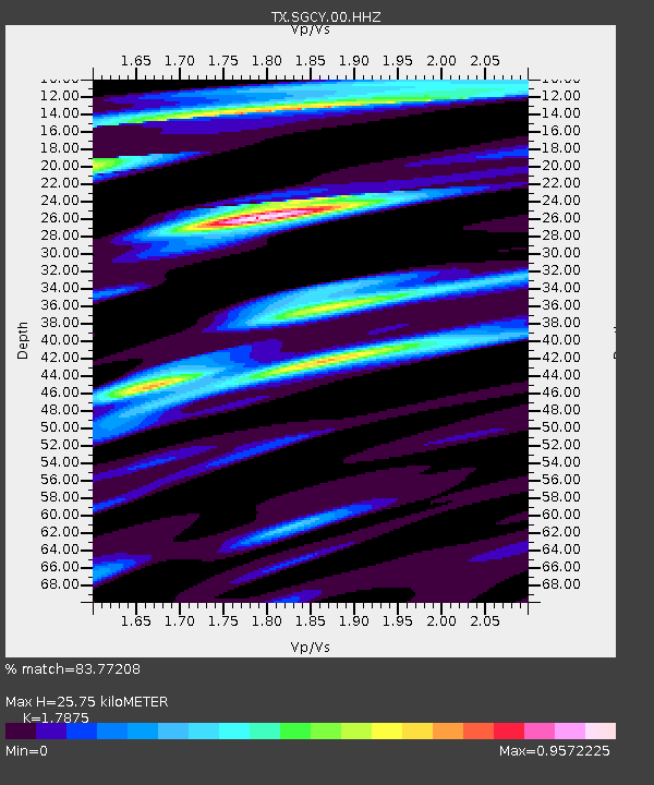
SGCY Sterling City - Earthquake Result Viewer
| Earthquake location: |
Near West Coast Of Honshu, Japan |
| Earthquake latitude/longitude: |
37.5/137.3 |
| Earthquake time(UTC): |
2023/05/05 (125) 05:42:04 GMT |
| Earthquake Depth: |
8.7 km |
| Earthquake Magnitude: |
6.2 mww |
| Earthquake Catalog/Contributor: |
NEIC PDE/us |
|
| Network: |
TX Texas Seismological Network |
| Station: |
SGCY Sterling City |
| Lat/Lon: |
31.91 N/101.13 W |
| Elevation: |
776 m |
|
| Distance: |
92.0 deg |
| Az: |
46.47 deg |
| Baz: |
317.338 deg |
| Ray Param: |
0.041531555 |
| Estimated Moho Depth: |
25.75 km |
| Estimated Crust Vp/Vs: |
1.79 |
| Assumed Crust Vp: |
6.38 km/s |
| Estimated Crust Vs: |
3.57 km/s |
| Estimated Crust Poisson's Ratio: |
0.27 |
|
| Radial Match: |
83.77208 % |
| Radial Bump: |
400 |
| Transverse Match: |
63.264538 % |
| Transverse Bump: |
400 |
| SOD ConfigId: |
30536071 |
| Insert Time: |
2023-05-19 06:24:14.017 +0000 |
| GWidth: |
2.5 |
| Max Bumps: |
400 |
| Tol: |
0.001 |
|

Signal To Noise
| Channel | StoN | STA | LTA |
| TX:SGCY:00:HHZ:20230505T05:54:41.724983Z | 9.192752 | 1.7895611E-6 | 1.9467087E-7 |
| TX:SGCY:00:HH1:20230505T05:54:41.724983Z | 3.8661067 | 4.163151E-7 | 1.07683285E-7 |
| TX:SGCY:00:HH2:20230505T05:54:41.724983Z | 1.6505373 | 2.8943023E-7 | 1.7535518E-7 |
| Arrivals |
| Ps | 3.2 SECOND |
| PpPs | 11 SECOND |
| PsPs/PpSs | 14 SECOND |


